ClimateData.ca has undergone a major redesign to make it easier than ever to find, understand, and use high-quality climate data. Meet the Updated ClimateData.ca.

Transportation Module Overview

Welcome to the Transportation sector information page. Learn how climate change impacts this sector, explore how climate information can be used in decision-making through case study examples, quickly access relevant climate data, and discover other resources to support adaptation planning.

The transportation sector module of ClimateData.ca provides easy access to important climate datasets, relevant resources, and case studies demonstrating the use of climate data in adaptation efforts for the Canadian transportation sector. This section explores potential climate impacts on the transportation sector from freeze-thaw cycles and temperature and precipitation extremes. Associated case studies demonstrate how both transportation infrastructure and operations can be adapted to withstand the impacts of climate change.


Climate Change and Transportation

Weather impacts all modes and facets of Canadian transportation systems, and changes to average and extreme weather and variability caused by climate change will exacerbate these impacts. Canadian transportation systems should therefore be designed, constructed, and maintained with future climate variability and change in mind. Providing transportation experts from diverse backgrounds (e.g. engineering, government, industry, academia) and transport modes (road, rail, marine, air) with access to reliable and sector-relevant climate information is crucial for fostering climate resiliency and helping to inform adaptation action in the transportation sector.

The case studies highlighted in this module are largely focused on the use of climate data to inform climate adaptation in the roads sector. Roads represent a significant proportion of transportation infrastructure, and road practitioners also represent a large user group for this module (65% of respondents to a survey during stakeholder engagement for the development of this module worked in the roads sector). The construction and maintenance of roads also has high economic impact, and it is perhaps for this reason that the roads sector has the most accessible examples of leadership in climate adaptation, thus far. However, the key lessons learned in the use of climate data to inform adaptation are broadly applicable across transport modes. Submissions of examples of climate adaptation in other modes of transport, for future inclusion on ClimateData.ca, are welcomed and encouraged, and can be provided in the Feedback section.

Examples of climate impacts affecting the various transport modes are explored below. Users are also directed to explore the Download page to download data that is relevant for them and their specific transport mode.

Temperature: Extremes

Extreme heat affects all modes of transportation and can result in the rutting and bleeding of roads, the warping of railway tracks, safety concerns for marine shipping, and weight restrictions for airplanes.1,2,3 In response to concerns about these climate impacts, transportation authorities throughout Canada are investing in temperature-smart decision-support tools and protocols to inform investments in transportation planning, construction, operations, and maintenance.

For example, Manitoba Infrastructure requires that bridges and large culverts are constructed of materials that can withstand an 80°C temperature range (-40°C to +40°C).3 Similarly, the Ontario Ministry of Transportation uses the Superpave system to identify appropriate heat- and rutting-resistant asphalt mixes for provincial highways and for some municipalities.3, 4

These guidance processes are a step forward for climate-smart engineering standards. However, it should be noted that they rely on historical climate data. As the trend for most of Canada is towards higher maximum temperatures (Figure 1), it will be necessary to account for projected future temperature change in transportation infrastructure design.

Figure 1. Increasing temperature extremes in Canada (Tmax > 37°C)

It is not only transportation infrastructure that will continue to be affected by extreme temperature, but also transportation services and operations. For transit authorities, extreme heat or cold can impact worker health and productivity at construction sites, and busses without air conditioning can have negative impacts on customer comfort and satisfaction.5 In the aviation industry, extreme cold can cause delays, while extreme heat can necessitate weight restrictions on some airplanes.6 Importantly, the temperature threshold that results in airplane weight restrictions will vary based on the location of the airport, the size of the aircraft, and the length of a runway.6

To help address different transport sector needs in different locations, the Analyze page on ClimateData.ca allows users to specify relevant thresholds for custom data downloads, for any location in Canada. Analysis of extreme temperatures may otherwise be explored with a number of parameters on the Variable page of ClimateData.ca, including hottest day, maximum temperature, and days with a maximum temperature at multiple thresholds.

Temperature: Freeze-Thaw Cycles

During periods of thaw, moisture from melting snow and ice is able to seep into cracks in infrastructure. When this moisture freezes and expands during freezing periods, infrastructure weakens and deteriorates.1,3

Greater variability in temperatures can therefore contribute to rapid deterioration of roads, and also of bridges, runways, taxiways, and railways.3 Reductions in the strength and in the stability of roadway infrastructure in turn increases the maintenance, renewal, and replacement costs.3  In northern Canada, these freeze-thaw cycles can perpetuate permafrost degradation, which has significant implications for northern transportation infrastructure.3 The integrity of railroad track is likewise reduced by rapid temperature cycling.5 Additionally, there are safety implications of freeze-thaw cycles as roads, sidewalks, and transit platforms may become slippery during these events and more uneven or unstable over time, therefore presenting increased slipping and tripping risks for users and workers.5

Throughout much of Canada, freeze-thaw cycles are expected to become more frequent in winter over the short-term, but freeze-thaw frequency may decline over the long-term as average winter temperatures rise (Figure 2).3,7 While the frequency of freeze-thaw cycles is still increasing, the potential for unsafe transportation conditions, rapid infrastructure deterioration, and maintenance costs will all rise as well.

Figure 2. Projections of freeze-thaw cycles in Canada over the 21st century

Freeze-thaw cycles are commonly calculated as the number of days when the air temperature fluctuates between freezing and non-freezing temperatures (i.e. when the daily maximum temperatures are greater than 0°C and the daily minimum temperatures are less than or equal to -1°C). For some applications, climate data users might be interested in different definitions of freeze-thaw cycles. For example, some users may be interested in the frequency of days for which there is more extreme freeze-thaw cycling (i.e. the daily maximum temperatures are greater than 2°C and the daily minimum temperatures are less than or equal to -5°C). These custom data extractions for freeze-thaw cycles can be defined and downloaded by users on the Download page.

Precipitation

Transportation authorities across Canada are grappling with the changing frequency and intensity of precipitation events. From washed out highways in BC, to flooded commuter rail tracks in Toronto, extreme precipitation events are impacting the transportation sector across Canada.3,8 Extreme precipitation events lead to a myriad of other risks in the transportation sector: vehicle collisions, construction delays, and reduced commuter comfort, for example.5,9,10 As total precipitation levels increase, or as the severity and frequency of extreme precipitation events increase, the climatic impacts on transportation infrastructure are forecast to increase as well.

Transportation authorities are familiar with designing their infrastructure and operations with weather and current climate conditions in mind; but a rapidly changing climate is a new challenge. In fact, like many road authorities in Canada, the Ontario Ministry of Transportation (MTO) had focused on observed climate data to inform their selection of culvert sizes based on historical precipitation intensity-duration-frequency (IDF) curves.3,11 However, in response to projected changes in precipitation due to climate change, new initiatives have emerged to develop IDF curve projections. The MTO now selects culvert sizes based on future projected rainfall to allow adequate future capacity for extreme precipitation events.11 The same kind of reflection and work has been done in Quebec with the Ministry of Transport, academics, and several collaborators.

In another example, Canadian engineers had already begun to notice that our infrastructure is vulnerable to increasing damage from extreme precipitation. Engineers Canada partnered with Natural Resources Canada and several other collaborators to create a protocol to assess the risks to public infrastructure: PIEVC (see our case study here). After some initial testing, the PIEVC Protocol was used by the BC Ministry of Transportation and Infrastructure to assess the risks created on the Coquihalla Highway by extreme precipitation.8 It was found that heavy rain and snow events, among other things, were already creating challenging, even unsafe conditions on the Coquihalla Highway (located in a mountainous, coastal region of BC).8

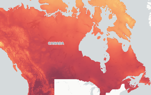
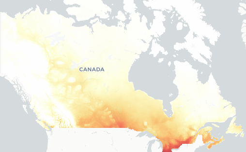
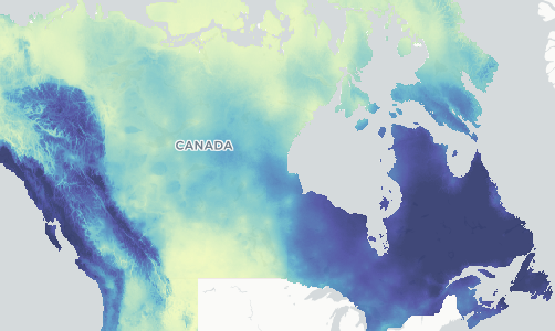
In some instances, decision makers require information about precipitation projections for specific situations. ClimateData.ca currently offers a range of precipitation datasets, including: total precipitation, maximum 1-day total precipitation, and wet days with more than 1, 10, or 20 mm of precipitation.

Further, some users may be interested in the frequency of days for which there is more extreme precipitation (e.g. the number of days with maximum precipitation greater than 27 mm). These custom data extractions for projected precipitation can be defined and downloaded by users on our Download page.


  1. City of Toronto. (2019). Pavement Design and Rehabilitation Guideline. Infrastructure Asset Management & Programming: Transportation Services Division. Toronto, ON. pp. 104. Available from: https://www.toronto.ca/wp-content/uploads/2019/04/9659-TS_Pavement-Design-and-Rehabilitation-Guideline.pdf
  2. Metrolinx. (2018). Metrolinx Climate Adaptation Strategy. Toronto, ON. pp. 36.  Available from: www.metrolinx.com/en/aboutus/sustainability/MX Climat Adapt_Str_May8_vs4.pdf
  3. Palko, K. and Lemmen, D.S. (Eds.). (2017). Climate risks and adaptation practices for the Canadian transportation sector 2016. Ottawa, ON: Government of Canada. pp. 320. Available from: https://www.nrcan.gc.ca/sites/www.nrcan.gc.ca/files/earthsciences/pdf/assess/2016/ClimatRisk-E-ACCESSIBLE.pdf
  4. Varamini, S., and Tighe, S. (2016). Mechanistic Evaluation of the Effect of Warm Mix Additives on the Strength and Durability of Typical Ontario SuperPave Mixes. In Proceedings of the Sixty-First Annual Conference of the Canadian Technical Asphalt Association (CTAA): Banff, AB
  5. Metrolinx. (2017). Planning for Resiliency: Toward a Corporate Climate Adaptation Plan September 2017. Available from: http://www.metrolinx.com/en/aboutus/sustainability/Planning_for_Resiliency_2017_EN_final.pdf
  6. Ryley, T., Baumeister, S., & Coulter, L. (2020). Climate change influences on aviation: A literature review. Transport Policy, 92: 55-64. Available from: https://www.sciencedirect.com/science/article/abs/pii/S0967070X20302870
  7. Boyle, J., Cunningham, M., & Dekens, J. (2013). Climate change adaptation and Canadian infrastructure. International Institute for Sustainable Development (IISD): Winnipeg, MB. Available from: http://www.redecouvrirlebeton.ca/assets/files/research/Climate-Change-Adaptation-and-Canadian-Infrastructure_Final_Nov2013.pdf
  8. Nodelman, J. (2010). Climate Change Engineering Vulnerability Assessment: Coquihalla Highway (B.C. Highway 5) Between Nicolum River and Dry Gulch. Nodelcorp. B.C. Ministry of Transportation and Infrastructure. Available from: https://www2.gov.bc.ca/assets/gov/driving-and-transportation/environment/climate-action/hwy5_coquihalla.pdf?forcedownload=true
  9. Andrey, J., Hambly, D., Chaumont, D., & Rapaic, M. (2013). Climate change and road safety: Projections within urban areas. Ottawa, ON: Transportation Association of Canada
  10. Markolf, S. A., Hoehne, C., Fraser, A., Chester, M. V., & Underwood, B. S. (2019). Transportation resilience to climate change and extreme weather events–Beyond risk and robustness. Transport Policy, 74: 174-186
  11. Ministry of Transportation of Ontario. (2016). DCSO-2016-14: Implementation of the Ministry’s Climate Change Consideration in the Design of Highway Drainage Infrastructure October 2016. Available from: https://www.library.mto.gov.on.ca/SydneyPLUS/TechPubs/Portal/tp/tmrmViews.aspx?lang=en-US

Blog posts

New and Noteworthy: Podcast pilot launch

February 5 2024
Rachel Malena-Chan, Canadian Centre for Climate Services

Using Climate Data to Assess Risks in the Transportation Sector

July 19 2022
Canadian Centre for Climate Services, Maginda Magendrathajan, Ryan Smith

Roads of the Future: How Climate Data can be Used to Adapt Our Roads to a Changing Climate

July 12 2022
Kari Tyler, Pacific Climate Impacts Consortium, Stacey O’Sullivan

Sector Resources

Climate Change Thresholds in the Transportation Sector

While using the Download page to download a custom selection of climate data is simple, finding out what climate threshold value(s) you should use may not be. Information on what thresholds to use in your specific context may be available from relevant transportation authorities, provincial guidelines, or academic research.

IDF Curves and Climate Change

Further information on using climate data or selecting a relevant historical dataset can be found in the Learning Zone. Further information on using climate data or selecting a relevant historical dataset can be found in the Learning Zone.

Learning Zone

Explore the wide range of information available to better understand and use climate data.

Download Page

For indices not included in the pre-calculated variable list, the Download page can be used to create custom indices, such as Heat Wave.

Stakeholder Engagement Methods

Through a bilingual survey, transportation stakeholders were consulted on the most useful climate information, indices, impacts, and learning resources for their transport-climate decisions. Here you can learn more about stakeholder feedback regarding what climate information is most needed to inform climate-smart decisions in the transportation sector.

Related Content

Climate Resilient Buildings and Core Public Infrastructure

The report provides a comprehensive assessment of the latest research on how climate-related hazards, including extreme heat events, wildfires, floods, and ice storms are affecting our health and wellbeing.

PIEVC Protocol

The Public Infrastructure Engineering Vulnerability Committee (PIEVC) developed the PIEVC Protocol for use in climate risk and vulnerability assessments of public infrastructure in Canada. Users can learn more about how to access and use the Protocol on the PIEVC Program website.

Adapting Transportation Infrastructure to Climate Change in British Columbia

For a complete list of PIEVC Protocol highway assessments conducted in British Columbia, practitioners can visit the “Adapting to Climate Change” section of the British Columbia government website. Readers can also explore other initiatives the Province has taken to evaluate and address the potential impacts of climate change on transportation infrastructure.

Map of Adaptation Actions

For additional adaptation case studies from across Canada, practitioners may want to explore the Map of Adaptation Actions recently released by Natural Resources Canada. Users of the Map can filter by sector to view transportation-specific case studies.

Advancing the Climate Resilience of Canadian Infrastructure

Transportation professionals may wish to review a 2021 report prepared by the International Institute for Sustainable Development (IISD) for Infrastructure Canada: “Advancing the Climate Resilience of Canadian Infrastructure: A review of literature to inform the way forward.” This report includes a review of current literature on climate change hazards, impacts, and adaptation options for six different types of built infrastructure across Canada, including that of land transportation.

Seasonal Forecasts

Looking for climate information for the more immediate future? Seasonal forecasts are coming to ClimateData.ca soon, but for the moment you can access short-term forecasts from Environment and Climate Change Canada.

Related Variables

Explore variables to learn about how data was used to impact climate related decisions in specific contexts.

Hottest Day

Extreme heat impacts all forms of transportation – it can cause rutting and bleeding of asphalt road surfaces, warping of railroad tracks leading to slow-go orders, as well as safety concerns for marine shipping and weight restrictions for airplanes.

View the variable

Days above Tmax

Extreme heat can impact customer comfort on public transit, as well as the health and productivity of transit workers. It can also lead to airline weight restrictions and delays.

View the variable

Maximum 1-Day Total Precipitation

High single day precipitation amounts can create challenging and unsafe conditions on highways, impact transit and result in vehicle collisions, construction delays, as well as reduced commuter comfort.

View the variable