ClimateData.ca has undergone a major redesign to make it easier than ever to find, understand, and use high-quality climate data. Meet the Updated ClimateData.ca.

Outdoor Recreational Trails and Climate Change

Date October 27, 2025
Author Caitlin Lichimo
Topics Climate Data in Action
Share this post

Introduction

Trails are more than paths – they are vital threads that connect communities, support local economies through nature-based tourism, and provide Canadians with opportunities for healthy recreation and spiritual renewal. Trail usage has surged in recent years, especially following the COVID-19 pandemic when access to the outdoors was a crucial outlet for Canadians.[1]

However, climate change is increasingly threatening the usability, safety, and longevity of trails. Those who use Canada’s trails extensively have been amongst the first to notice these changes. A recent survey of Canadian Rocky Mountain guides found that almost all have observed environmental changes in their guiding areas over their careers, including warmer summers and winters, more rain in winter, and greater variability in snowpack.[2]

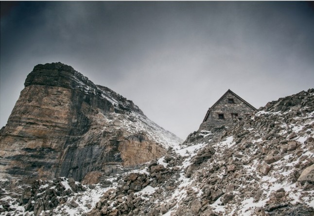
Mountain infrastructure is also at risk. For example, the historic Abbot Pass Hut in Banff National Park had to be permanently closed and dismantled in 2022 after melting permafrost and eroding slopes undermined its foundation.[3]

In this article, we examine how climate change is impacting trails across different regions of Canada and highlight how data from ClimateData.ca can help park officials and trail users plan.

Abbot Pass Hut in Banff, Alberta.

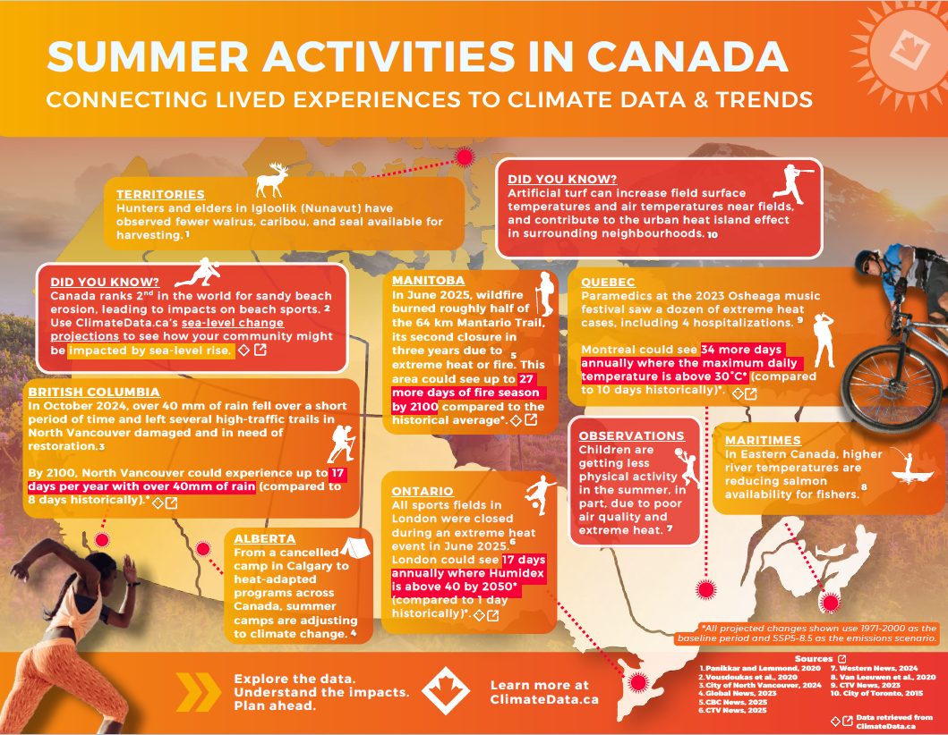
Summer Recreation and Climate Change Infographic

From music festivals and fishing to trail hiking and summer camps, many forms of recreation in Canada are already being affected by a warming climate. Events in recent years — and especially the summer of 2025 — highlight how heat, heavy rainfall, wildfire, and shifting ecosystems are reshaping the ways Canadians experience summer. The accompanying infographic illustrates these impacts across regions, connecting lived experiences of recreation to broader climate data and trends.Click here to download this infographic as a PDF.

Warming Temperatures and Visitor Experience in Parks

Weather and climate strongly influence outdoor recreation. Comfortable temperatures, sunshine, and the absence of rain and high winds are key factors determining visitor satisfaction according to a survey of visitors to Ontario’s provincial parks. In fact, these park visitors identified comfortable temperature ranges for summer recreation as described in Table 1.

Table 1. Temperature preferences of visitors in two Ontario provincial parks (adapted from Hewer et al., 2014).
Time of DayAverage Ideal TemperatureIdeal RangeUnacceptably CoolUnacceptably Hot
Day (July–Aug)27.4 °C24–31 °C15.6 °C34.8 °C
Night (July–Aug)19.7 °C17–23 °C8.7 °C28.7 °C


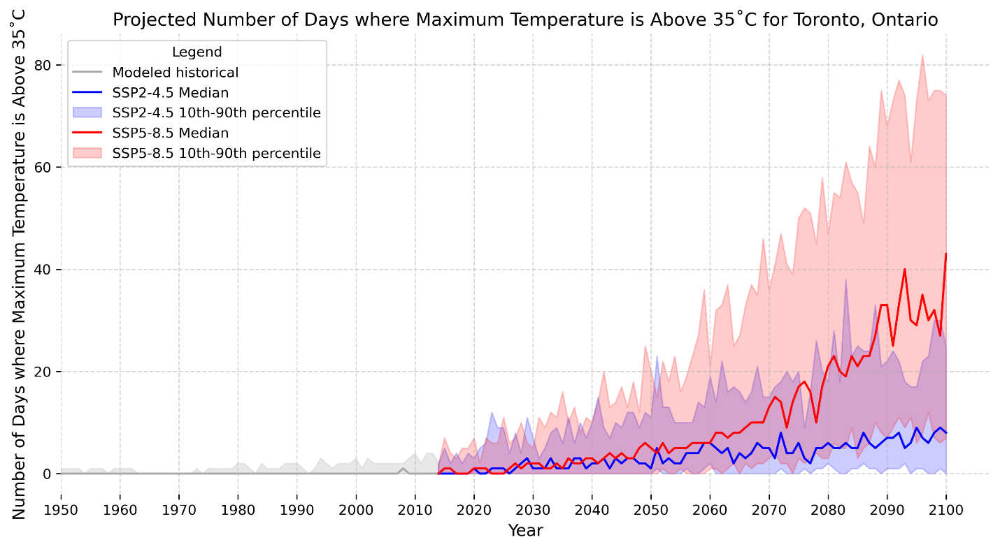
Based on this survey, the study authors concluded that park visits in Ontario could rise 15-56% by the 2050s due to warmer weather and its impact on the length of the hiking season [4]. However, an increase in the frequency and intensity of unacceptably hot days (days above ~35 °C) may have the opposite effect in the longer term and shift park visits to other seasons. Data from ClimateData.ca can be used to explore projected changes in extreme heat under different emissions scenarios. For example, historically Toronto experiences less than one day that exceeds 35°C per year [5] (click here to find climate normals for your community). Under a high-emissions scenario (SSP5-8.5), Toronto could average 24 of these very hot days by 2071-2100 (Figure 1).


Figure 1: The projected number of days with maximum temperature above 35°C for Toronto, Ontario under a moderate emissions scenario (SSP2-4.5; Blue) and a very high emissions scenario (SSP5-8.5; Red) from 1950 to 2100 (gray delineates the historical modelled period).

Wildfire Smoke and Trail Closures in Western Canada

In recent summers, wildfires fueled by heat and drought have caused widespread trail closures and air quality hazards, especially in western Canada.

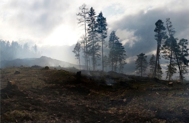
British Columbia is no stranger to climate-induced wildfires. In late June 2021, a record-breaking heat dome broke Canadian temperature records, priming the landscape for wildfire. Dozens of popular trails were closed that summer due to wildfires – from Mount Robson in the Rockies to coastal parks around Whistler, Pemberton, and Tofino. 

Hikers and cyclists in the Kootenays were unable to pursue their outdoor activities in August, when thick smoke was on the trails, obscuring views and creating unhealthy conditions.

“It seems like every summer now you get to the second week of August and you can’t see anything, you’re sucking in smoke .… [I]t poses all sorts of challenges… for backcountry riding, because it’s a short season to start with, a significant part of that is poor air.”– Stewart Spooner, Trails Operations Manager, Kootenay Columbia Trails Society (2024 interview).

In 2023, over 15 million hectares of land burned in Canada, over seven times the annual average area burned in recent decades. This record-setting fire activity had far-reaching impacts on air quality. At the time of writing, 2025 is set to become the second-worst fire season on record in Canada in terms of area burned. In 2025, several recreational areas were forced to close or were damaged in Manitoba, including the Mantario Trail.

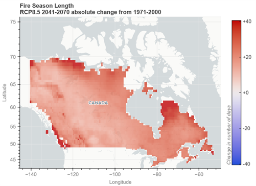
Using the Fire Weather Index App on ClimateData.ca, trail planners and emergency managers can explore projections for metrics like fire season length or build-up index (BUI) for their specific area. For example, the app indicates that fire season length is projected to increase across the country (Figure 2). Fire season length projections do not estimate the number, size, or intensity of wildfires. However, lengthening of the fire season, as well as projections that show an increase in the severity of fire weather conditions, indicate that fire danger in Canada is projected to increase in a warming climate. A longer fire season generally results in a greater likelihood of poor air quality events.

Figure 2: This map shows the absolute change by 2041-2070 from 1971-2000 in the fire season length under the RCP8.5 emissions scenario. The fire season length metric represents the annual count of days in the fire season (days when wildfires are likely to start and spread). The fire season begins after three consecutive days with daytime maximum temperatures greater than 12°C. The fire season ends after three consecutive days of daytime maximum temperatures remaining below 5°C. The interactive fire weather app allows users to hover over the map to get specific values, as well as change the time period, emissions scenario, and more.

Extreme Rainfall, Coastal Storms, and Coastal Trail Damage

As the climate warms, so too does the potential for larger, more powerful storms. In Atlantic Canada, there is concern that warmer sea-surface temperatures could lead to more powerful hurricanes. These hazards, combined with rising sea levels, can pose additional risks to outdoor recreation trails.

One recent example was Hurricane Fiona in September 2022, which struck Eastern Canada as a powerful post-tropical cyclone, bringing record-breaking rainfall and storm surges. Parts of Nova Scotia, Prince Edward Island, New Brunswick, and Newfoundland saw 50 to 200 mm of rain within 24 hours, causing severe flooding.

Along the coast, storm surge waves over 3 m high pounded the shore. Sections of the Cabot Trail in Cape Breton were washed out or buried by landslides, multiple parks and campgrounds were forced to close, and coastal trails experienced significant beach and soil erosion. Governments had to invest tens of millions of dollars to rebuild damaged roads, bridges, and trail sections – for example, over $40 million was allocated to repair infrastructure in Cape Breton Highlands National Park and surrounding areas.[6] One iconic seaside footpath, the Louisbourg Lighthouse Trail, required about $158,000 in emergency repairs and renovations funded by the province.[7]

Hurricane Fiona underscored how compound climate extremes can overwhelm trail systems: heavy precipitation plus rising sea levels and strong winds can lead to destructive flooding. Climate change is expected to make such events more likely. Warmer ocean and air temperatures are already yielding rainier and windier hurricanes, and storms are tracking further north than before.[8] [9] Future projections indicate these trends will continue, meaning Atlantic Canada must brace for more frequent high-impact storms (see Box 2).
 

Box 2: What is Driving Stronger Hurricanes?

Hurricanes are fueled by warm ocean water. Climate change has increased Atlantic sea surface temperatures, which means more energy and moisture for storms. Rising temperatures also enable storms to hold more water vapor (about 7% more rain per 1 °C of warming in general). Additionally, some studies suggest hurricanes are moving more slowly and reaching farther north as the climate warms. The combination of these factors leads to hurricanes that are rainier, longer lasting, and reaching regions (like Atlantic Canada) not historically accustomed to such extremes. Read the whole article on Climate Change and Hurricanes in Atlantic Canada here: Hurricanes and Climate Change in Atlantic Canada — ClimateData.ca

ClimateData.ca offers tools to explore local relative sea-level change projections for coastal communities and indices for heavy precipitation. Maps of projected relative sea-level change can highlight which low-lying trail segments or access roads are likely to be below high-tide lines in a few decades. Likewise, projections of “wet days” (e.g. days with >20 mm rain) can alert park managers to the likelihood of more frequent intense downpours in the coming decades.

Adapting Trails for a Changing Climate

What these climate data and information make clear is that climate change threatens to alter the conditions for which trails were originally designed. Rising heat, longer fire seasons, heavier rain, and coastal storms all create pressures that trail managers must address. While no single solution works everywhere, several broad approaches are emerging [10], including:

  • Strengthening Infrastructure: Trails and facilities can be reinforced or relocated to withstand hazards. Examples include rerouting alpine paths away from unstable permafrost zones, raising bridges in flood-prone areas, or creating fuel breaks to reduce wildfire risk. These investments can prevent costly maintenance, repairs, and health and safety issues.
  • Adjusting Operations and Seasons: Trail schedules are shifting in response to new climate patterns. For example, alpine climbs are being scheduled earlier in the day and trail managers are adapting to much busier shoulder seasons as visitors alter their schedules to avoid summer heat. Projections of future hot days or fire weather help managers understand how conditions may change so they can adjust their operations.
  • Nature-Based Solutions: Restoring wetlands, dunes, or forests can buffer trails from heavy rain, storm surge, and erosion, while enhancing biodiversity. For example, “living shoreline” projects in Nova Scotia have successfully protected coastal paths.[11]
  • Policy and Cultural Shifts: Not all trails can be maintained indefinitely. Sometimes the sustainable choice is limiting access to protect ecosystems or cultural values. Indigenous leadership is central to identifying areas where recreation must adapt to land stewardship priorities, especially as those priorities change with a changing climate.

Conclusion

Trails connect people to nature and support physical, mental, and community well-being. Yet, as we have outlined, climate change poses multifaceted challenges to the future of outdoor trails. Extreme heat, wildfire and smoke, storms, coastal erosion, and other climate-related disturbances are already impacting how and when we can use trails, as well as the cost and effort required to keep them safe. These impacts are likely to intensify in the coming decades. The trail community – from government agencies to volunteers on the ground – is rising to the challenge, combining traditional knowledge with modern climate projections to chart a sustainable path forward.

References

[1] Trans Canada Trail. (2025). The IMPACT of Trails. Retrieved on October 3, from: Trans Canada Trail | The IMPACT of Trails

[2] Rushton, B., & Rutty, M. (2023). Gaining insight from the most challenging expedition: climate change from the perspective of Canadian mountain guides. Current Issues in Tourism26(23), 3903–3915. https://doi.org/10.1080/13683500.2023.2185506

[3] Hik, D., Robinson, Z., and Slemon, S. (2022). The Abbot Pass hut, an iconic mountain refuge, is dismantled — due to climate change. Canadian Geographic.

[4] Jones, B. & Scott, Daniel. (2006). Climate Change, Seasonality and Visitation to Canada’s National Parks. Journal of Parks and Recreation Administration. 24. 42-62.

[5] Government of Canada. (2025). Canadian Climate Normals 1991-2020 Data. Retrieved on October 3, from: Canadian Climate Normals 1991-2020 Data – Climate – Environment and Climate Change Canada.

[6] Government of Canada. (2023). Government of Canada Announces Infrastructure Improvements in Parks Canada administered places in Cape Breton/Unama’ki With $43 million investment.

[7] Government of Nova Scotia. (2023). Funding for Trail Restoration in Cape Breton.

[8] Madge, C., & Smith, R. (2024). Hurricanes and Climate Change in Atlantic Canada. ClimateData.ca. Retrieved on October 3, from: Hurricanes and Climate Change in Atlantic Canada – ClimateData.ca.

[9] Morris, M. (2025). Climate Change and Strong Winds. ClimateData.ca. Retrieved on October 3, from: Climate Change and Strong Winds – ClimateData.ca

 [10] Pröbstl-Haider, U., Hödl, C., Ginner, K., & Borgwardt, F. (2021). Climate change: Impacts on outdoor activities in the summer and shoulder seasons. Journal of Outdoor Recreation and Tourism34, 100344.

[11] Canada in a Changing Climate. (n.d.). The Town of Mahone Bay Living Shoreline. Retrieved on October 3, from: The Town of Mahone Bay Living Shoreline — Canada in a Changing Climate