Ask a Climate Expert: Fantastic File Formats and How to Use Them

Welcome to another post in our “Ask a Climate Expert” series where we address real-life questions that have been sent to the Canadian Centre for Climate Services’ Support Desk. Our Support Desk team receives a wide range of questions from people who are using climate data to make climate-smart decisions. We’ll be sharing some answers to commonly asked questions in a digestible way. Our goal is to make climate data accessible for everyone, not just climate scientists.

In this post, we’re going to explore file formats. Professionals from across sectors like transportation, health, and engineering access climate data to assess vulnerability, identify potential impacts, and plan for resilience. Along the way, they may download climate data for a particular region or timeframe to apply in practice. Whether you’re new to using climate data or an experienced climate researcher, understanding these formats will help empower you to make the most of the climate data available on ClimateData.ca.

Below is a list that details the common file formats that you will find throughout the website. An FAQ section related to these data formats follows.

Data

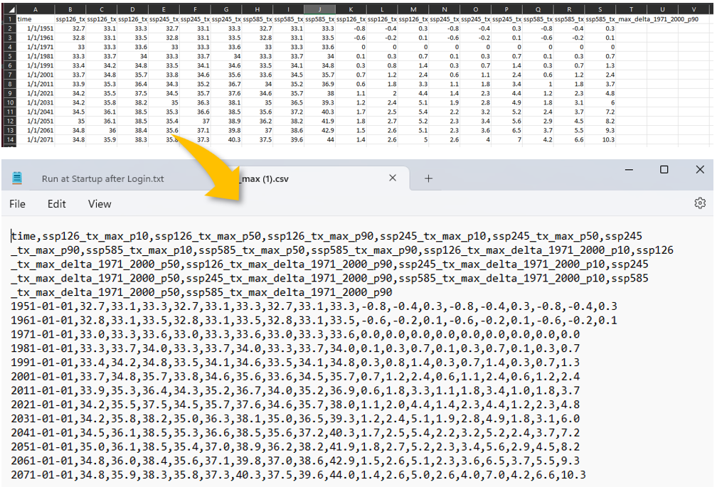
  • CSV: The first and most common format you’ll come across on ClimateData.ca is the CSV file. The CSV, or Comma-Separated Values, file saves data in a format that can be easily opened using spreadsheet programs like Microsoft Excel or Google Sheets.
  • NetCDF: NetCDF stands for Network Common Data Form file. This file format is commonly used to store multi-dimensional data such as climate data, where there are multiple attributes like time steps, many spatial dimensions (i.e., coordinates) and climate variables like temperature and precipitation. A NetCDF file can be used in programming environments, for example by using PAVICS: Power Analytics and Visualization for Climate Science. Unfortunately, spreadsheet programs like Microsoft Excel will be unable to display data from these types of files, but if you want to quickly visualize the information in a NetCDF, you can download the free program Panoply from the NASA website.
  • JSON: JSON is shorthand for JavaScript Object Notation file. This format is often used to store data that has multiple attributes and is commonly used to exchange data between a server and a web application. JSON data is organized as “key-value” pairs, where each key is a string, followed by a colon, and then its associated value(s).
  • GeoJSON: A GeoJSON file is a specific type of JSON file that stores geographical information, specifically coordinates. They are commonly used in mapping and Geographic Information Systems (GIS) applications to represent and share place-based data.

Figures

  • PDF: PDF stands for Portable Document Format file. PDF files are commonly used to store image and text data and can be read by Adobe Acrobat Reader or Preview on Mac, or by using any web browser like Chrome. One of the benefits of this file type is that its layout is preserved, no matter what kind of device or software is used to open the file. Most of the time, PDF files are not editable. On ClimateData.ca, this format is one of the options for downloading figures and maps.
  • PNG: PNG is short for Portable Network Graphics file. PNG images are used to display images. Unlike other popular image formats, including GIF and JPEG, PNG files preserve transparent or semi-transparent backgrounds, making them particularly useful when layering one image overtop another. This kind of file can be opened by most image viewing programs or can be opened by using any web browser. On ClimateData.ca, this format is one of the options for downloading image versions of the figures and maps.

File format FAQs

Q: In the context of climate-related risk assessments and adaptation planning, what are the pros and cons of using CSV, NetCDF, JSON, or GeoJSON as a file format?

A: The choice between CSV, NetCDF, JSON, and GeoJSON for climate-related assessments hinges on the project’s complexity and the user’s technical skills. CSV is simple and widely compatible but lacks support for complex data. NetCDF excels in handling multi-dimensional data for scientific analysis but requires more technical knowledge. JSON is versatile and human-readable, ideal for data interchange, but less efficient for large datasets. GeoJSON specializes in geographical data, offering good support for mapping applications but shares JSON’s limitations with large or complex data sets. Ultimately, the decision should align with the user’s comfort with programming and the specific needs of their project.


Q: Is NetCDF data the best option to select if I am hoping to integrate this climate data into a GIS (Geographic Information System), for example to layer geo-coded infrastructure data on top of the data?

A: Yes, NetCDF data is a viable option for integrating climate data into a GIS for layering geo-coded infrastructure data. Its ability to handle multi-dimensional data allows for detailed analysis and visualization within GIS platforms. Experts can manipulate NetCDF to extract specific space-time slices, converting them into raster formats for easier use and sharing in GIS contexts.


Q: Is there a file format considered the gold standard for most needs (NetCDF for e.g.,)?

A: The term “gold standard” for file formats like NetCDF is subjective and varies with user needs and technical capacity. No single format is universally best; choice depends on the project’s scale, data complexity, and the user’s familiarity with climate data. NetCDF is favored for its ability to handle large, multi-dimensional datasets, making it ideal for detailed analysis by experienced users. Simpler formats like CSV may better suit beginners or those needing straightforward data overviews. The best file format aligns with the specific requirements and expertise of the user.
As you journey deeper into the world of climate data, these file formats will be your trusty companions. Stay tuned for more posts in our “Ask a Climate Expert” series, where we’ll continue to break down complex climate concepts into digestible information. Until then, keep the questions coming and happy data downloading!