In recent decades, Canada has experienced an increase in insured catastrophic losses, with thunderstorm-driven hazards, including heavy rains, high winds, and hail, constituting a significant portion of these losses[1]. This article synthesizes current scientific understanding and recent research findings to assess the impacts of climate change on the key atmospheric ingredients required for thunderstorm formation in Canada: moisture, atmospheric instability, a trigger, and wind shear.
Thunderstorm Ingredients
Thunderstorms and their associated hazards, which include hail, high winds, flooding rains, tornadoes, and lightning, pose substantial risks to infrastructure, agriculture, and communities across Canada. The formation of these convective storms depends on a specific set of atmospheric conditions: moisture availability, atmospheric instability, a triggering mechanism, and, for severe thunderstorms, adequate wind shear. Climate change is anticipated to alter these conditions, affecting the frequency, intensity, and duration of thunderstorm events.
Our series on Hazards connects climate data to weather hazards to build the climate literacy of Canadians.
By understanding the prerequisites for thunderstorm formation, we can better anticipate how climate change could impact the frequency, intensity, and location of these storms in a changing climate.
1. Moisture
Adequate moisture is a key first ingredient. The more moisture available, the more intense a thunderstorm can become. Because the capacity of the atmosphere to hold moisture increases by approximately 7% for every 1°C of warming (the so-called Clausius-Clapeyron relationship), a warmer atmosphere is expected to be more humid. Warm temperatures increase evaporation rates from bodies of water and transpiration from agricultural crops and forests, further enhancing the potential for high water vapour content in the atmosphere. For these reasons, climate scientists expect that thunderstorms are likely to produce increased precipitation amounts in the future in certain areas[2],[3].
2. Atmospheric Instability
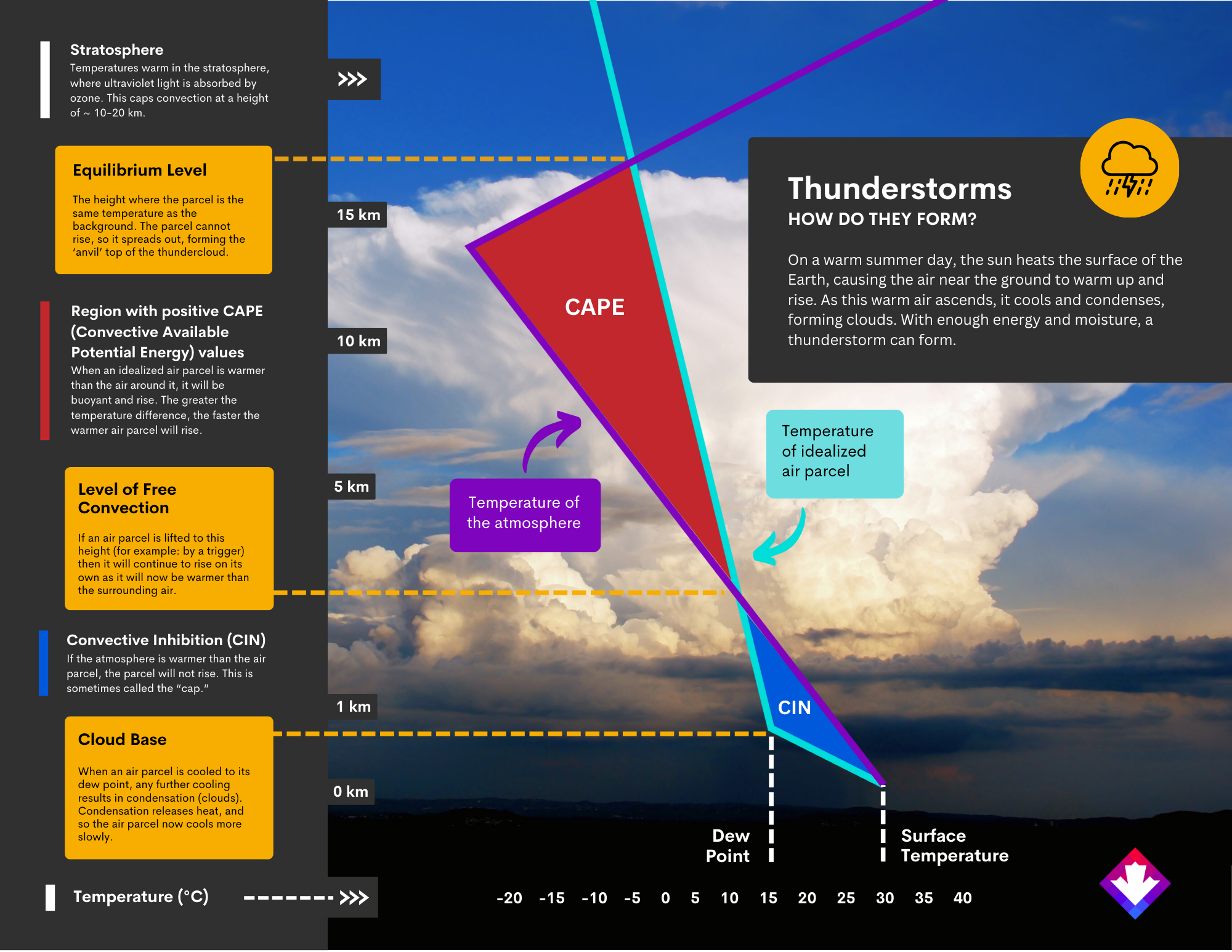
On a clear summer day, the Earth’s surface warms due to solar heating. Warm surface air is less dense than cold air and thus rises. Importantly, as air rises it also cools. This happens because air pressure decreases with height, causing the air parcel to expand, meaning the same amount of heat now occupies a larger volume. This is called adiabatic cooling – changing the temperature of the air without changing its heat content. If this air cools off too fast, then it will no longer remain warmer than its surroundings – and its upward journey will slow or stop.
Meteorologists describe the energy (“fuel”) available for parcels of air to rise in the atmosphere as CAPE, short for Convective Available Potential Energy. It describes the instability of the atmosphere and provides an approximation of updraft strength within a thunderstorm. Convective inhibition (CIN) is the amount of energy needed to initiate convection, to lift a parcel of air to its level of free convection (LFC). High values of CAPE indicate a greater potential for severe weather, and therefore CAPE is another measure of a thunderstorm’s potential intensity. Generally, surface-based cape values (SB-CAPE) of 1000 J/kg or greater have ample energy to form thunderstorms, while SB-CAPE values over 2500 J/kg are associated with severe thunderstorms.
High CAPE values can arise from high surface temperatures caused by solar heating. Less obvious, however, is the role of water vapour in the calculation of CAPE. When air cools to its saturation point (100% relative humidity or its dew point temperature), any further cooling will cause condensation, releasing heat back into the air, keeping a parcel of air warmer than it would otherwise be.
Conditions are particularly favorable for high CAPE values when cold, dry air overlies hot, humid surface air. Such conditions are often found during the summer in the lee of the Rocky Mountains, where air, having been forced to rise, cool, and dry over the mountains, moves over the relatively hot, humid air of the central American Plains and Canadian Prairies. This setup contributes to the existence of ‘Tornado Alley’, where not only is there sufficient moisture moving northward from the Gulf of Mexico, but the juxtaposition of cold, dry air aloft enhances the contrast between the surface and upper air conditions.
What is CAPE?
CAPE is a measure of the amount of energy available for convection. Convection is a process that involves the upward movement of warm, moist air. This is a key ingredient in the formation of thunderstorms. Warmer surface temperatures can lead to more evaporation, putting more moisture into the air. When this warm moist air rises and cools off, the water vapor condenses into clouds. The higher the CAPE, the more potential energy is available to drive severe weather, including thunderstorms.
As global warming increases surface temperatures and increases humidity via evaporation, it can lead to an increase in CAPE, potentially making the atmosphere more conducive to severe thunderstorms.
Observed trends in CAPE in the U.S.
A study by Climate Central found that, since 1979, the eastern U.S. has experienced an increase in the number of days with high CAPE values, particularly during spring and summer, correlating with heightened thunderstorm potential. In contrast, the western U.S. has seen a decrease in such days. A similar pattern is expected for southern Canada. For a detailed overview, visit Climate Central.
Global historical CAPE data
The ERA5 reanalysis dataset by the ECMWF is a global resource providing historical weather and climate data, including CAPE. Typical thunderstorm environments show CAPE values over 1000 J/kg, with extremes surpassing 5000 J/kg. Access to this dataset is available through the Copernicus Climate Data Store.
Thunderstorms: how do they form?
Having large CAPE values and sufficient moisture does not always mean a thunderstorm will form. Importantly, there must be an accumulation of warm, moist air that then undergoes rapid release, akin to opening a valve on a container of compressed gases; without this, the energy dissipates slowly, reducing severe weather potential. Meteorologists use the term ‘cap’ to refer to a small amount of convective inhibition, or CIN, which stops free convection from occurring, allowing the energy to build. Overcoming the cap, therefore, is a critical next ingredient for thunderstorm formation. Often, this is achieved by something called a ‘trigger’.
3. Triggers
A trigger is a mechanism that initiates rapid upward air movement, overcoming a cap and catalyzing the lifting process. There are many ways to trigger a storm, but some of the most common include mountains, convergent wind zones, and weather fronts.
Mountains serve as effective triggers by forcing air to ascend and condense. This is why the windward side of a mountain range receives so much more precipitation than its leeward side. However, even modest topographical variations can act as triggers; sometimes a change of just a few metres in elevation can make the difference. Convergence zones, or regions where air currents from multiple directions meet, is another common type of trigger. When surface air collides, it has nowhere to go but up. These vertical winds lift the hot, humid surface air.
Frontal zones, delineating the boundaries between two air masses with distinct temperature and humidity profiles, can also act as triggers. Cold fronts, where a mass of cold air advances into a warmer air mass, and warm fronts, when warm air moves into region of cold air, are the two most common types of fronts. Due to its higher density, cold air rapidly displaces warm air at the surface, thus lifting the warm air, making the intersection of fronts particularly effective triggers for convective activity.
Thunderstorms in Quebec
The impact of climate change on thunderstorms in Quebec is a subject of ongoing research. Model projections suggest that warming temperatures may drive increased atmospheric instability, potentially leading to more frequent thunderstorms. This would align with simulations indicating a rise in the frequency and intensity of short-duration, heavy precipitation events across much of the province. However, uncertainties remain regarding changes in the strength of storm-associated violent winds and lightning, with no scientific consensus reached on these aspects yet.
For more detailed information, you can visit Ouranos’ page on thunderstorms and lightning.
4. Wind shear
Moisture, instability, and a trigger mechanism are necessary for generating thunderstorms capable of flooding rains, lightning, and high winds. However, the formation of the most severe thunderstorms, capable of producing violent winds and tornadoes, requires the addition of one more ingredient: wind shear. Wind shear refers to variations in wind velocity or direction, or both, with altitude. Typically, winds accelerate at higher altitudes due to reduced friction with the Earth’s surface, where terrain, vegetation, and structures introduce resistance.
Wind shear’s role in severe thunderstorm development is complex. In a simplified scenario without wind shear, rising warm, moist air would cool, condense, and precipitate in a single location. Cold rain effectively extinguishes the storm. With stronger upper-level winds, it is possible for the storm to tilt, causing rain to fall away from its source of surface heat and moisture. This separation between the updraft (warm rising air) and downdraft (cooling rain) enables the storm to sustain itself and grow, despite the cooling effect of precipitation. Additionally, winds varying in direction with altitude can induce rotation within the thunderstorm, transforming it into a severe system known as a supercell. Supercell thunderstorms can produce violent tornadoes.
How will climate change impact wind shear?
The Arctic is warming about three times faster than the global average, a phenomenon often referred to as Arctic amplification. This has several effects, including melting ice and snow, but relevant here, it also affects atmospheric circulation patterns. As the Arctic heats up, it narrows the surface air temperature differences between the circumpolar Arctic and mid-latitudes, affecting the jet stream and, theoretically at least, reducing mid-latitude wind shear. Wind shear is a critical factor in the development and severity of thunderstorms, particularly in organizing and sustaining them. Consequently, changes in wind shear due to climate-induced alterations in the jet stream could influence thunderstorm patterns. However, this impact is regional and more research is required to understand how climate change may affect the frequency, intensity and spatial distribution of thunderstorms.
Supercell Thunderstorms
Supercell thunderstorms are a distinct class of convective storms characterized by a deep, rotating updraft, known as a mesocyclone. Supercells can sustain themselves for several hours, potentially producing significant hail, torrential rainfall, strong winds, and tornadoes. While supercells can form anywhere under suitable conditions, they are most frequent in areas like the Great Plains of the United States and the southern Canadian Prairies.
Conclusion
Climate change is expected to affect convective storms in Canada by altering key atmospheric conditions necessary for their formation, including moisture availability, atmospheric instability, and wind shear.
Climate models project a rise in Convective Available Potential Energy (CAPE) across many parts of North America, suggesting the potential for more frequent and more severe thunderstorms in the future. Alongside CAPE, climate models indicate that extreme precipitation events are likely to increase in frequency and severity in many areas of Canada. This increase is often attributed to the Clausius-Clapeyron relationship, the principle that a warmer atmosphere has an increased capacity to hold moisture.
Wind shear, crucial for the development of severe thunderstorms, including supercells, is more difficult to model and study. Arctic amplification is generally expected to result in decreased wind shear across the mid-latitudes, which may decrease severe thunderstorm occurrence in some locations. Over some regions, studies suggest increased CAPE may be sufficient to overcome changes in shear, resulting in more severe thunderstorms.
While some parts of Canada might see an environment increasingly conducive to severe weather due to a warming atmosphere during the next century, the interaction of numerous factors, including wind shear, introduces complexities that make it difficult to know for certain how thunderstorm hazards are likely to change in the future as the planet continues to warm. More research is needed to strengthen our understanding of the extent to which climate change will impact the intensity and frequency of thunderstorms in particular locations in Canada.
The paper “Future Global Convective Environments in CMIP6 Models” by Lepore et al., examines the global impact of climate change on conditions conducive to severe convective storms using CMIP6 model projections. The findings demonstrate that with each degree Celsius increase in global temperature, the frequency of environments favorable for severe weather could rise by 5%-20%. This increase is more pronounced in the Northern Hemisphere’s higher latitudes, where it is primarily driven by a substantial rise in CAPE. This study underscores the complex relationship between global warming and atmospheric conditions that may lead to severe weather, indicating a need for further research and refined modeling techniques.
Lepore, C., Abernathey, R., Henderson, N., Allen, J. T., & Tippett, M. K. (2021). Future Global Convective Environments in CMIP6 Models. Earth’s Future, 9(12), e2021EF002277.
Footnotes
[1]Insurance Bureau of Canada, 2022. Severe Weather in 2021 Caused $2.1 Billion in Insured Damage (ibc.ca)
[2]Lepore, C., Abernathey, R., Henderson, N., Allen, J. T., & Tippett, M. K. (2021). Future Global Convective Environments in CMIP6 Models. Earth’s Future, 9(12), e2021EF002277. https://doi.org/10.1029/2021EF002277
[3]The actual amount of water vapour the atmosphere holds on any given day will depend on adequate moisture availability, which will depend on several other factors, not just atmospheric temperature. In places like the Canadian Prairies, moisture advection from the Gulf of Mexico can be the dominate source of atmospheric moisture during summer months, for example.