Get Climate Smart: El Niño

Introduction

ClimateData.ca specializes in providing long-term projections of future climate. While these projections are essential for building resilience to climate change, many users also require an understanding of shorter-term climate variations from year to year and month to month. These fluctuations, including changes in temperature and precipitation, are driven by the inherent internal variability of the climate system. This variability influences regional climate conditions across Canada, often masking long-term trends in the near term.

For many regions in Canada, a key driver of this variability is the El Niño-Southern Oscillation (ENSO) cycle. ENSO alternates between warmer and cooler phases known as El Niño and La Niña. These phases influence global weather patterns because the climate of different places is connected, referred to formally as “teleconnections” (Box 1). ENSO teleconnections play an important role in modulating temperatures, precipitation, and even the frequency and intensity of extreme weather events across the world.

Box 1: What are climate teleconnections?

Teleconnections, a term derived from “tele,” meaning “at a distance,” describe the phenomena where weather and climate patterns in one region are influenced by climate events occurring thousands of kilometers away. The study of these patterns helps scientists understand how different parts of the climate system are interconnected.

Teleconnections occur, in part, because the climate system is linked by planetary-scale circulation patterns called Rosby Waves [1]. Rosby Waves form as air and water move between warmer and colder regions. The Earth’s rotation steers these waves, forming undulating, river-like patterns in both the atmosphere and oceans [2]. Unlike the vertical motion of waves observed on a beach, Rossby waves primarily move horizontally and can extend across thousands of kilometers. Rossby waves can create persistent patterns of weather (high or low pressure) that are stable over weeks or even months. These circulation patterns can act like a seesaw: when pressure is high in one area, it tends to be lower in the connected region.
ENSO - El Niño-Southern Oscillation

El Niño is one phase of a larger, naturally recurring climate pattern called the El Niño-Southern Oscillation (ENSO), which is driven by shifts in trade winds over the Pacific Ocean. ENSO can drive widespread, multi-year impacts on global weather patterns, influencing everything from ocean temperatures to rainfall. This pattern is discussed in both the Importance of Using 30 Years of Data and Natural Variability Learning Zone articles due to its important impact on climate variability.

ENSO events manifest through periodic shifts in sea surface temperature (SST) and sea-level pressure (SLP) across the tropical Pacific Ocean, with SST fluctuations reaching 1 to 3°C above or below average. The ENSO cycle consists of three phases: El Niño, the warm phase; La Niña, the cool phase; and a neutral phase during the transition. This cycle’s impact is global, affecting weather patterns across regions, including North America, with influences on tropical rainfall and cascading weather effects worldwide.

El Niño

During El Niño, SSTs rise in the central and eastern tropical Pacific, leading to a weakening or reversal of the east-to-west wind patterns usually observed at these latitudes. This shift disrupts the westward transport of warm water, allowing it to accumulate near South America. Warm water is less dense than cold water, meaning sea levels rise as the water warms. This can be detected by satellites and is one of the ways the arrival of El Niño is detected. Changes in SLP across the Tropical Pacific are also used to detect and measure the strength of ENSO events (Box 2).

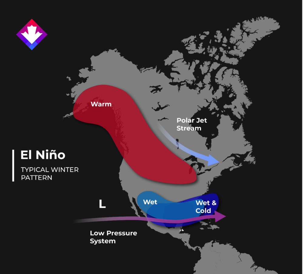
Importantly for Canadians, the Pacific jet stream shifts southward during an El Niño, modifying weather patterns across North America. El Niño typically results in warmer and drier winters in northern US and Canada (Figure 1).

Human-caused greenhouse gas emissions have already added substantial warmth to the climate system. When an El Niño event occurs, this background warming combines with natural warming patterns, increasing the chances of extreme high temperatures.

Box 2: measuring ENSO

ENSO’s phases are monitored in many ways. The Oceanic Niño Index (ONI), which computes SST anomalies in designated Niño regions along the equatorial Pacific, is one common index. The ONI provides a measure of the intensity and phase of El Niño or La Niña events by averaging these temperature deviations over several months. Changes in atmospheric pressure, as indicated by the Southern Oscillation Index (SOI), are also critical for predicting ENSO phases. The SOI measures the pressure differences between Darwin, Australia, and Tahiti, reflecting the strength of the easterly trade winds and their influence on oceanic and atmospheric circulation.

Figure 1: El Niño typically results in warmer and drier winters in northern US and Canada

La Niña

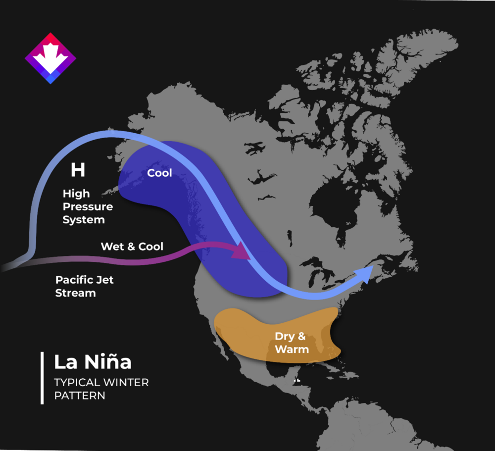
During La Niña, ocean surface temperatures cool in the central and eastern tropical Pacific as the typical east-to-west trade winds intensify, pushing warm water westward towards Australia. This shift causes the Pacific jet stream to move northward, resulting in colder, wetter conditions in the Pacific Northwest, which can increase the likelihood of heavy rains and flooding in this region. For Canada, La Niña often brings a colder and snowier winter to western provinces, particularly British Columbia and the Prairies, and can lead to increased snowfall in parts of Ontario and Quebec. In contrast, the southern United States tends to experience drier-than-normal conditions during La Niña (Figure 2).

Figure 2: La Niña often brings a colder and snowier winter to western provinces, particularly British Columbia and the Prairies, and can lead to increased snowfall in parts of Ontario and Quebec. In contrast, the southern United States tends to experience drier-than-normal conditions during La Niña

Conclusion

Understanding ENSO and its role in influencing global and regional weather patterns is key to making sense of some of the variability in average annual temperatures and, recently, the extreme temperatures we’ve experienced. While human-caused climate change is the driving force behind long-term warming trends, natural phenomena like El Niño can temporarily amplify observed warming. It is important to recognize the role of teleconnections, such as ENSO, in shaping the weather we experience. By studying these interactions, scientists can improve seasonal forecasts and develop better climate models, helping us prepare for future climate challenges. In upcoming articles, we will explore other important teleconnections and their impact on Canada’s climate.

Articles referenced directly in this post

Additional resources used