Understanding Fire Weather and Climate Change Basics 

Canadian wildfire activity is increasing in part because human-caused climate change is causing more hot and dry weather conditions conducive to wildfires, also referred to as “fire weather”.   Future patterns of fire weather will look different from the past – conditions have already changed and will continue to do so. Understanding this change will be important for building resilience to wildfires.

Key Messages

  • Climate change has already impacted wildfire activity (wildfire frequency and severity) in Canada and will continue to do so.
  • Wildfire frequency and severity are largely determined by weather conditions, available fuel (vegetation), and ignition sources.
  • The Canadian Forest Fire Weather Index (FWI) System is used to understand the effects of weather on fire danger.
  • The Fire Weather Projections application for Canada presents future fire weather projections based on the FWI System under a changing climate.

Canadian wildfire activity is increasing in part because human-caused climate change is causing more hot and dry weather conditions conducive to wildfires, also referred to as “fire weather”.1As climate change progresses, longer fire seasons and worsening fire weather conditions are expected in many regions of Canada, leading to more intense and frequent wildfires.2,3 Future patterns of fire weather will look different from the past – conditions have already changed and will continue to do so. Understanding this change will be important for building resilience to wildfires. 

To help Canadians respond to shifting wildfire danger, the Fire Weather Projections application provides future projections of fire weather using visuals and data. This guidance article, and others, are available in the application to help users confidently apply this information.

What factors influence wildfire activity?

Wildfires are a common natural occurrence in Canada and play a critical role in the ecology of forests, grasslands, and other ecosystems. In addition to naturally ignited fires, Indigenous peoples have used cultural burning for millennia to steward ecosystems and biodiversity. Generally, wildfires occur more often and are more severe when there is:

  1. Hot, dry, and windy weather. These conditions make it easier for fires to start and spread.
  2. A lot of flammable vegetation and debris. This fuel can be standing trees, forest floor debris, and underground material. The more fuel there is to burn and the more flammable the fuel, the more likely it is that a fire will ignite and grow.
  3. More ignition sources to start fires. In Canada, roughly half of all wildfires are started naturally by lightning, and roughly half are human-caused.4  The more ignition events, the more likely it is for wildfires to take hold.

Together, these three factors are often referred to as the fire regime triangle – and characterize the key drivers of regional fire activity. The information in the Fire Weather Projections application focuses on the weather aspect of the fire regime triangle and how this will evolve as the climate changes. However, due to direct human activity and climate change, vegetation and ignition sources will also change over time. For example, forestry operations may change the type and amount of vegetation, affecting the fuel available to burn. Due to climate change, lightning – which historically has started roughly half of Canadian wildfires – is becoming more common in regions where it was relatively uncommon in the past.5  This app provides data on how fire-conducive weather conditions are projected to change in a changing climate. For a more holistic assessment of future wildfire danger, this information should be evaluated alongside considerations of how fuels, ignition sources, and the landscape are projected to change.

The fire regime triangle. Climate (the long-term statistics of weather) is one of three key factors that affect wildfire activity.

How does fire danger fit into overall fire risk?

Wildfire risk considers both the likelihood and severity of a wildfire (in this case, the “hazard”) combined with the consequence of a potential fire, including what things are present (“exposure”) and how vulnerable those things are to fire (“vulnerability”). As described above, fire weather is one factor that affects potential fire frequency and severity, which, in turn, is one aspect of overall wildfire risk. This is illustrated in the graphic below. 

The relationship between fire weather and wildfire risk. Climate (the long-term statistics of fire weather), ignitions, and vegetation are three key factors that affect fire danger and ultimately wildfire activity – in this case, the hazard of concern. In turn, this hazard can be related to wildfire risk by also considering the vulnerability and exposure of at-risk communities. Fire weather is only one of several components that must be considered to assess overall wildfire risk.

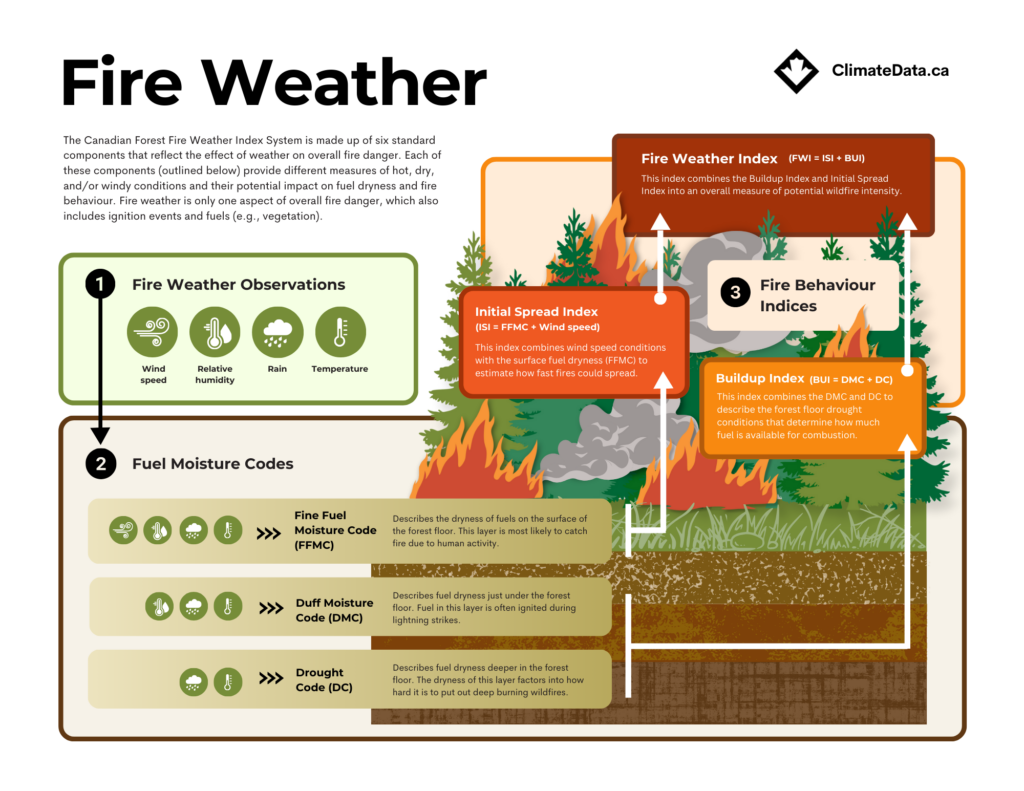
What is the Canadian Forest Fire Weather Index System?

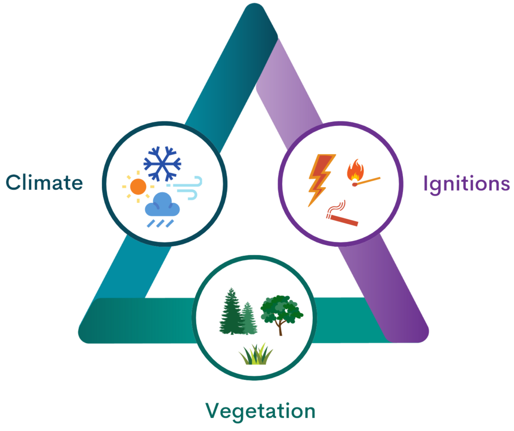
Canadian forest fire professionals use the Canadian Forest Fire Danger Rating System (CFFDRS) to estimate wildfire danger, or the potential for wildfire ignition, spread, and intensity. The CFFDRS considers all the factors in the fire regime triangle, as well as other wildfire controls like topography (landscape features). Within the CFFDRS, fire weather is described by a system called the Canadian Forest Fire Weather Index (FWI) System. Because it is widely used for wildfire planning in Canada, the future fire weather data provided in the Fire Weather Projections application is based on this system. Understanding FWI System basics is one important part of understanding future wildfire danger.

The FWI System is comprised of codes and indices that reflect the potential impact of weather on different aspects of wildfire. Each of these, described below, provides different measures of hot, dry and/or windy conditions and their potential impact on wildfire.

The first three FWI System components are called the fuel moisture codes, because they describe the dryness of wildfire fuel at different layers of the forest floor based on weather conditions.6

  • The Fine Fuel Moisture Code (FFMC) describes the dryness of fuels on the surface of the forest floor. This layer is most likely to catch fire due to human activity.
  • The Duff Moisture Code (DMC) describes fuel dryness just under the forest floor. Fuel in this layer is often ignited during lightning strikes.
  • The Drought Code (DC) describes fuel dryness deeper in the forest floor. The dryness of this layer factors into how hard it is to put out deep burning wildfires.7

The last three FWI System components describe how wildfires might behave, if started.

  • The Buildup Index (BUI) combines the DMC and DC to describe the forest floor drought conditions that determine how much burnable material is available as wildfire fuel.
  • The Initial Spread Index (ISI) combines wind conditions with surface fuel dryness (FFMC) to estimate how fast fires could spread.
  • The Fire Weather Index (FWI) combines BUI and ISI into an overall measure of potential wildfire intensity.8,9

Each of the FWI System codes and indices become larger as the weather becomes drier, hotter, and/or windier – as fire weather gets worse. Due to differences in forest type (the wildfire fuel), FWI System values are interpreted differently depending on the region. For example, each Province and Territory uses the FWI System in slightly different ways to understand fire danger (e.g., different thresholds for “extreme” fire danger). Knowledge of regional characteristics is key for using FWI System values in local planning.

What future fire weather projections are available in the application?

Environment and Climate Change Canada has used climate model projections to determine estimates of changing FWI System indices through the 21st century. The resulting data product, which may be accessed via the Fire Weather Projections application, is called CanLEAD-FWI.10

In CanLEAD-FWI, six FWI System components are estimated from 1950 to 2100 on a grid of approximately 50 km by 50 km. Standard metrics describing projected changes to high fire weather severity and frequency, as well as fire season length have been precalculated. These metrics, available in gridded format, describe how climate change will impact the severity, frequency, and duration of fire-conducive weather conditions. For users familiar with the FWI System, locally relevant thresholds can be used within the application to calculate customized metrics over the entire 1950 to 2100 period. These customizable metrics are only available for locations with historical station-based observations.

For more information on interpreting and using CanLEAD-FWI, as well as data limitations, see the Guidance tab in the application, including:

  • How is fire weather different from fire behaviour?
  • How can I consider the impact of climate change on fire weather?
  • Which FWI System component should I use for my assessment?
  • Which emissions scenario should I use?
  • How are station-based projections different from gridded projections? What is available to users?
  • Learn more about the climate model inputs and methods.

References

  1. KirchmeierYoung, M. C., Gillett, N. P., Zwiers, F. W., Cannon, A. J., & Anslow, F. S. (2019). Attribution of the influence of human‐induced climate change on an extreme fire season. Earth’s Future, 7(1), 2-10. https://doi.org/10.1029/2018EF001050
  2. Coogan, S. C., Daniels, L. D., Boychuk, D., Burton, P. J., Flannigan, M. D., Gauthier, S., … & Wotton, B. M. (2021). Fifty years of wildland fire science in Canada. Canadian Journal of Forest Research, 51(2), 283-302. https://doi.org/10.1139/cjfr-2020-0314
  3. Wang, X., Parisien, M. A., Taylor, S. W., Candau, J. N., Stralberg, D., Marshall, G. A., … & Flannigan, M. D. (2017). Projected changes in daily fire spread across Canada over the next century. Environmental Research Letters, 12(2), 025005. https://doi.org/10.1088/1748-9326/aa5835
  4. Hanes, C. C., Wang, X., Jain, P., Parisien, M. A., Little, J. M., & Flannigan, M. D. (2019). Fire-regime changes in Canada over the last half century. Canadian Journal of Forest Research, 49(3), 256-269. https://doi.org/10.1139/cjfr-2018-0293
  5. Chen, Y., Romps, D. M., Seeley, J. T., Veraverbeke, S., Riley, W. J., Mekonnen, Z. A., & Randerson, J. T. (2021). Future increases in Arctic lightning and fire risk for permafrost carbon. Nature Climate Change, 11(5), 404-410. https://doi.org/10.1038/s41558-021-01011-y
  6. Natural Resources Canada. Background information: Canadian Forest Fire Weather Index (FWI) System. Accessed on: 2024-03-14. Available at: https://cwfis.cfs.nrcan.gc.ca/background/summary/fwi 
  7. Wotton, B. M. (2009). Interpreting and using outputs from the Canadian Forest Fire Danger Rating System in research applications. Environmental and Ecological Statistics, 16, 107-131. https://doi.org/10.1007/s10651-007-0084-2
  8. Van Wagner, C.E., 1987. Development and structure of the Canadian Forest Fire Weather Index System, Forestry Technical Report. Minister of Supply and Services Canada, Ottawa. 
  9. Lawson, B.D., Armitage, O.B., 2008. Weather guide for the Canadian Forest Fire Danger Rating System. Northern Forestry Centre, Edmonton. 
  10. Van Vliet, L., Fyke, J., Nakoneczny, S., Murdock, T. Q., & Jafarpur, P.(2023). Developing user-informed fire weather projections for Canada. Climate Services, 35. https://doi.org/10.1016/j.cliser.2024.100505