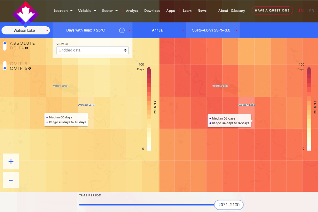
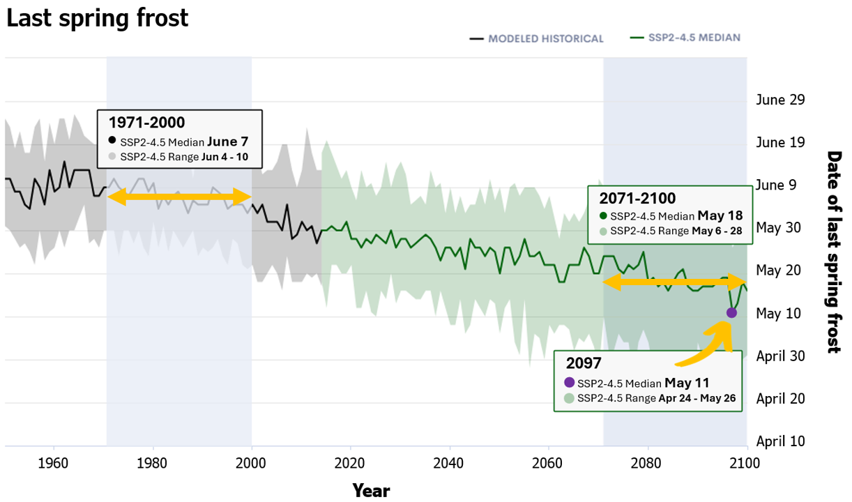
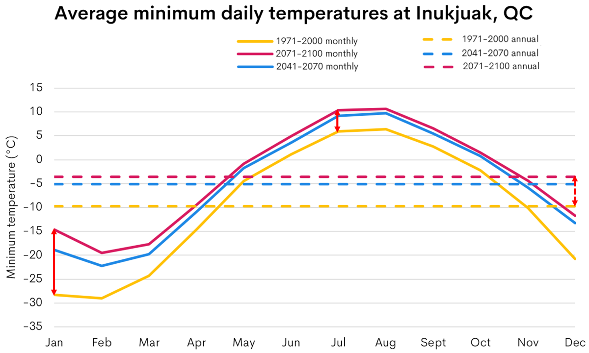
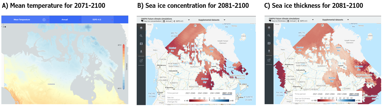
Monthly & Seasonal Forecasts now on ClimateData.ca: Learn what’s new, Explore the map.

Getting started with Western science-based climate data for northern Canada

This article describes best practices for using future and historical climate data for decision making in the North.

Module

Northern Climate Data Resources

Format

Article

Time to completion

25 minutes

This article can be explored in 3 formats:

Full article

(continue reading below)

Infographic

(click to download)

Print friendly infographic

(click to download)

Tips to start using Western science-based climate data for northern decision-making

In our Overview of Available Western Science-based Climate Data for Northern Canada, we explore a variety of Western science-based climate datasets. While the climate datasets found on ClimateData.ca stem from Western science, the partners behind the platform recognize the value of Indigenous Science and Knowledge Systems in supporting Indigenous-led adaptation planning. In this context, Western climate science can be considered as an additional piece of information to support Indigenous Peoples, and their self-determined climate actions.

This article dives a bit deeper into climate science and discusses seven best practices when incorporating climate data into decision-making:

  1. Plan for the future: Use climate projections to inform planning and design for the North
  2. Explore uncertainty: Use an ensemble of future climate projections for a more robust analysis
  3. Explore multiple futures: Look at a range of emissions scenarios
  4. Think climate, not weather: Consider average conditions over 30 years
  5. Investigate seasonal changes: Consider seasonal and monthly values, in addition to annual values
  6. Look at the bigger picture: Consider more than one climate variable to better understand local climate
  7. Stay updated: Keep an eye out for new datasets

Additional tips are discussed in Best Practices for Choosing and Using Western Science-based Climate Data for Northern Canada.

1. Plan for the future: Use climate projections to inform planning and design for the North

Relying on historical climate data is no longer sufficient for informing future plans and actions. Canada is warming at a faster rate than the global average, and this is amplified in northern regions.1 For example, if we relied on data from 1971-2000 or 1991-2020, and assumed it would be suitable for future planning, we would not be adequately prepared for the future because historical averages are lower than the projected temperature increases, even for a low emissions scenario (Figure 1).

Figure 1: Projected annual mean temperature for Rankin Inlet, NU this century under three emissions scenarios: SSP1-2.5, SSP2-4.5, and SSP5-8.5. Projections are based on the Coupled Model Intercomparison Project (CMIP6) multi-model ensemble. The solid lines illustrate the multi-model means. Note that ensemble spread is not shown. The dashed lines indicate the historical average temperature for the 1971-2000 (light blue) and 1991-2020 (pink) periods.

Consideration of future climate data in decision-making has many benefits including:

  • Helping people plan for future changes, develop strategies for adaptation, and reduce their vulnerability to climate extremes;
  • Designing infrastructure that is safer and more resilient to current and future climate; and
  • Reducing costs over the long term by avoiding expensive system and infrastructure adjustments and failures. 2

If we take an example of a northern community wanting to design and build a new community centre, accounting for future climate will result in a building that is more resilient to the changing climate. Incorporating climate projections means that appropriate building materials are used, heating and cooling systems are designed to cope with future conditions, and adaptation options are implemented that will lead to resilient, safe and comfortable buildings.


Western climate science can support decisions for different timescales. For the immediate term, weather forecasts can predict hourly to weekly weather conditions. For the medium term, seasonal-to-decadal forecasts are available at monthly to 10-year timescales, bridging the gap between weather forecasts and climate projections. For the longer term, climate projections or simulations are available to the end-of-century. In this article, we will focus on considerations when using climate projections.

Climate projections are available at different spatial resolutions, ranging from approximately 10 km² to 250 or more. Climate projections represent the average conditions over the area defined by the grid-cell resolution of the climate model. Consequently, finer resolution model projections, that use smaller grid-cell areas, are more likely to represent the influence of local landscape features on the climate, such as small lakes, mountains and valleys. It is helpful to consider the spatial resolution of climate model projections when using climate data in decision-making.

Climate projections are available for a wide range of climate variables and indices. While “variable” and “index” are sometimes used interchangeably, the terms define different types of data. In climate science, a variable is a measurable property of the Earth’s physical climate system, like temperature, precipitation, wind, or sea level. This data is often available as minimum, maximum and mean (average) values or accumulated totals (for precipitation). An example of a variable is “Daily Minimum Temperature”, which represents the coldest temperature of the day and is often shown as an average for monthly, seasonal, or annual time periods.

A climate index is derived from climate variables and often uses a threshold value in its calculation. An example of a climate index is “Ice days”, which counts the number of days when the warmest temperature of the day (i.e., maximum temperature) remains below freezing during a given timeframe (i.e., the threshold value used is 0°C). Internationally, the Expert Team on Climate Change Detection and Indices (ETCCDI) has defined a set of climate indices that provide a comprehensive overview of temperature and precipitation statistics. 3

ClimateData.ca provides more than 40 future climate variables and indices for almost all locations in Canada. Ouranos and the Pacific Climate Impacts Consortium (PCIC) also provide high quality future climate data through portals such as Climate Portraits for Quebec (including Nunavik), and the Design Value Explorer which provides access to future design values for bridge and building construction for most of Canada (including 75 locations north of 55˚N), respectively.


2. Explore uncertainty: Use an ensemble of future climate projections for a more robust analysis

Let’s look at an example of a policymaker working for a local government. This person has been tasked with working on a climate change adaptation plan for their region. When presented with a wealth of climate data, it can be tempting to want to ask, “which of these models is the best?” or “which model should I use?”. Relying on output from a single model is not recommended. Instead, an ensemble of climate models should be used because it provides a more robust picture of how the climate may change.

Figure 2: Evolution of annual-mean near-surface temperature changes in Yellowknife, NT under SSP5-8.5 from CanDCS-M6 simulations (coloured lines). All values are relative to the 1971-2000 mean (black zero line).

An ensemble dataset provides a range of outputs from multiple “runs”, or simulations, from one or more climate models in response to an imposed forcing (e.g., a scenario of future greenhouse gas and aerosol emissions). Each simulation represents a possible future under those forcing conditions. Every time a climate model is run, it produces a plausible representation of the future climate, and each run will be different (Figure 2). These differences stem from the fact that each model represents climate processes slightly differently. Using many models increases the likelihood of capturing the possible range of future climate conditions that could occur under a particular emissions scenario.4


If only a single climate model is available (e.g., a regional climate model), it is best practice to use a large number of runs from that model to create an ensemble dataset. This involves running the same model many times with slightly different initial conditions (i.e., the starting points for model runs that are typically based on historical climate conditions). The outcome of this ensemble enables an assessment of the range of plausible future climates that could occur under a particular emissions scenario (for more details on this topic see Section 5.2 from the Climate-Resilient Buildings And Core Public Infrastructure Report: Plain language summary)5. Using multiple runs from a single model and a single emissions scenario enables an assessment of how natural climate variability, as represented by that model, can affect the simulated climate. For example, PCIC’s Design Value Explorer data is derived from single-model, multi-run ensembles.

Figure 3: Time series of mean annual temperature for 1900-2100 for a region including Canada and adjacent waters (40°N to 75°N and 140°W to 55°W) for CMIP6 GCMs. The panels highlight different types of uncertainty in climate model projections and their various influences. A) Natural variability from a single GCM (CanESM5) simulation for SSP8-8.5). B) Model uncertainty from many individual GCM simulations for SSP5-8.5. C) Emissions scenario uncertainty is illustrated by the different colours used for the 3 emissions scenarios. D) The same information as Figure 3-C, but in summary format. The bold line represents the ensemble median for each emissions scenario and their respective ranges of results (shaded envelopes that represent the 10th and 90th percentiles). This figure combines the uncertainty due to natural variability, model uncertainty and emissions scenario uncertainty.

Figure 3 shows three different sources of uncertainty in climate model projections using annual average temperature as an example:

  • Natural variability: Figure 3-A shows the evolution of annual average temperature from a single run of a single climate model. The year-to-year variation illustrates the natural variability of the climate system, as represented by that particular model. This single simulation also shows the response of the climate system to the emissions scenario SSP5-8.5 (the increase in temperature over time).
  • Model uncertainty: Figure 3-B illustrates climate model uncertainty using a multi-model ensemble, i.e., the response of multiple climate models to the same emissions scenario. Each model represents climate processes slightly differently and therefore simulates a different climate response to the same emissions scenario. The spread of model results provides a representation of model uncertainty.
  • Emissions scenario uncertainty: Figure 3-C shows the climate response of multiple models to three different emissions scenarios, represented by the different colours.
Figure 3-D shows the same information as Figure 3-C, but in a summary format, where the bold line represents the ensemble median for each emissions scenario and the shaded areas represent their respective ranges of results (in this case, the 10th and 90th percentiles of the multi-model ensemble). These types of figures combine the uncertainty due to natural variability, model uncertainty and emissions scenario uncertainty.

Figure 4: Projected annual mean temperature for Carmacks, YT, this century under four emissions scenarios: SSP1-2.6 (blue), SSP2-4.5 (green), SSP3-7.0 (orange), and SSP5-8.5 (red). Projections are based on the multivariate downscaled CanDCS-M6 dataset. The bold lines show the multi-model median, and the shaded areas represent the 10th and 90th percentiles used to show the range of model results.

The multi-model ensembles available on ClimateData.ca for CMIP5 and CMIP6 contain results from more than twenty different climate models for several different emissions scenarios. Using many different climate models in an ensemble captures the uncertainty that comes from differences in how the individual models represent climate processes. Results from multi-model ensembles are generally reported as summary statistics to facilitate interpretation. On ClimateData.ca, the ensemble range is defined using the 10th and 90th percentile values, and the median (50th percentile) is used to show the mid-point of the ensemble (Figure 4).  The Climate Atlas uses the same summary statistics but uses the ensemble-mean (average) rather than the median value.  

Understanding the full range of possible climate futures is important when making decisions and preparing for the future. You can learn more about climate model ensembles in these articles: Understanding Multi-Model Ensembles and Understanding Ranges in Climate Projections.

3. Explore multiple futures: Look at a range of emissions scenarios

Since we don’t know exactly what the future will look like, many multi-model ensembles have data available for a range of possible future emissions scenarios. These possible futures are driven by different emissions of greenhouse gases and aerosols which, in turn, depend on things like land use changes, population, economic growth, climate policy, global conflict, and technology advances. The CMIP6 climate model ensemble uses emissions scenarios known as Shared Socio-Economic Pathways (SSPs; Figure 5), while Representative Concentration Pathways (RCPs) were used with the preceding CMIP5 ensemble.

Five SSPs have been developed by the international scientific community. These pathways can be characterized in terms of the socioeconomic challenges they imply for mitigating and adapting to climate change (Figure 1). There is value in looking at multiple scenarios because it can help you understand the range of possible future climates.

On ClimateData.ca, four emissions scenarios can be used to explore different possible futures 6:

  • SSP1-2.6: a pathway of sustainable development with lower emissions, a scenario of ~3°C of warming for Canada by 2100 (~2°C globally), similar to RCP2.6
  • SSP2-4.5: a pathway of middle-of-the-road development with moderate emissions, a scenario of ~4°C of warming for Canada by 2100 (~3°C globally), similar to RCP4.5
  • SSP3-7.0: a pathway of regional rivalry with higher emissions, a scenario of ~6°C of warming for Canada by 2100 (~4°C globally)
  • SSP5-8.5: a pathway of fossil-fuel development with higher emissions, a scenario of ~7°C of warming for Canada by 2100 (~5°C globally), similar to RCP8.5.

The availability of both SSP3-7.0 and SSP5-8.5 allows users to select the high-end scenario that best aligns with their specific needs. In many situations, it makes sense to stress test a system by looking at the highest plausible scenario. ClimateData.ca allows you to compare the results of two emissions scenarios side by side (Figure 6).

Figure 5: The Five Shared Socioeconomic Pathways and the associated challenges to mitigation and adaptation.

When considering climate over the next 20 to 30 years (to ~2050), there is little difference between the emissions scenarios and the resulting climate projections. 6 If you are making a decision that will only influence the next three decades, the choice of emissions scenario will not be that impactful.  For example, if you’re working at a local health authority and want to help your community prepare for extreme heat over the next 25 years, you could choose any of the emissions scenarios to determine how extreme heat may change in the future. Climate projections for different emissions scenarios start to diverge after ~2050. Building on the previous example, if your team is retrofitting or developing a community centre or hospital that will function for many decades, it is best practice to consider a range of emissions scenarios because the associated climate projections diverge beyond the 2050s (as illustrated in Figure 4).

One factor that could influence the choice of emissions scenario is the risk tolerance for the project, which is often determined during discussions with colleagues, stakeholders, rightsholders, and the broader community. If the risk tolerance for a project is low, it will be necessary to consider the emissions scenario which leads to the largest climate response, e.g., if extreme heat is the main concern, the emissions scenario exhibiting the greatest warming should be considered. If the risk tolerance for a project is higher, a more middle-of-the-road emissions (such as SSP2-4.5) scenario could be considered. Considerations for choosing emissions scenarios is further discussed in the article Understanding Shared Socio-economic Pathways (SSPs).

Figure 6: ClimateData.ca screenshot showing a comparison of the number of days where the maximum temperature is hotter than 25°C in Watson Lake, YT by the end of the century under SSP2-4.5 (left) and SSP5-8.5 (right).

4. Think climate, not weather: Consider average conditions over 30 years

Weather can vary significantly from day to day and year to year, making it difficult to distinguish long-term trends from short-term natural climate variability. Typically, statistics based on 30 years of data are used to describe climate conditions.  A 30-year period is considered long enough to capture the influence of most natural and human-made forcing factors on the climate system. The length of period can also provide a baseline, or reference, for changes to be assessed against. For example, future climate conditions at the end of the century (2071-2100) can be compared with a historical reference period such as 1971-2000 or 1991-2020. Data for a single year, or for 5- or 10-year periods, may be dominated by the effects of natural climate variability, which can mask the longer-term climate trends.

For example, suppose the community of wants to understand how climate change might affect its long-term food security, particularly the seasons for gathering and gardening. Frost occurrence is shaped by microclimate and local topography. Climate change can impact patterns of frost occurrence in complex and location-dependent ways that make estimating future local changes difficult.7 Despite these complexities, climate projections, when paired with local knowledge and site-specific validation, can be a powerful tool to support climate-informed decisions.

For this community, the last spring frost may be considered an indicator of the start of the growing and planting season. If a specific year, such as 2097, is used to determine the date of the last spring frost, the date would fall in early May (May 11) by the end of the century (Figure 7). However, if the 30-year average value for the end of the century is used, the average date of occurrence of the last spring frost is mid-May. Relying on a projection for a single year could lead to an assumed start date for the planting season that is early, which might result in overly optimistic projections of future crop growing potential.

Considering average conditions over 30 years provides a clearer picture of observed and projected trends, allowing people to explore a range of long-term strategies and to adapt in a way that is resilient to the evolving climate.

Figure 7: Historical and projected date of first fall frost in Rigolet, Nunatsiavut (NL) this century under a moderate emission scenario (SSP2-4.5). Projections are based on the CanDCS-M6 multi-model ensemble available on ClimateData.ca. This image depicts how looking at the data for a small window of time, such as the year 2097, could be misleading compared to looking at a trend over a longer period (2071-2100).

5. Investigate seasonal changes: Consider seasonal and monthly values, in addition to annual values

Looking at climate variables at seasonal and monthly timescales, can lead to different impacts. For example, changes in winter snowpack can lead to changes in spring and summer flood regimes. Examining monthly or seasonal changes is especially useful when working with variables that exhibit opposing seasonal trends. For example, while annual precipitation may be increasing, summer precipitation may be decreasing. This is important to be aware of in cases where the seasonality of this change can have important adaptation implications.  Integrating Indigenous Knowledge Systems and local knowledge alongside Western-based climate data can help interpret the potential impacts of climate change at seasonal scales.

Figure 8 shows an example of daily minimum temperatures, averaged by month, for Inukjuak in Nunavik (QC). Changes in variables like daily minimum temperature, when looked at by month, can help contextualize the loss of cold and how seasons are projected to shift over time. If only annual temperature is considered, a ~6 °C change between 1971-2000 and 2071-2100 is projected, which might camouflage some important seasonal changes. In this case, January temperatures are projected to increase by ~14°C, while July temperatures are projected to increase by 5°C, indicating that winters are projected to warm faster than summers.


Let’s imagine a local health authority trying to manage their resources and capacity. In their region, the annual temperature is only projected to increase by a few degrees, which may not seem large enough to impact service provision. However, when the seasonality of these changes is examined, summer temperatures are projected to warm significantly, which could lead to more heat stress. Winter temperatures are also projected to increase, which could lead to a reduction in cold-related illnesses and hypothermia, and to more accidents from ice-related activities.

Figure 8: Downscaled CMIP6 (CanDCS-M6) ensemble mean monthly (solid lines) and annual (dashed lines) average minimum daily temperatures in Inukjuak, QC for 1971-2000 (yellow), 2041-2070 (blue), and 2071-2100 (pink) under SSP2-4.5. The solid red arrows note the difference in January and July temperature changes between 1971-2000 and 2071-2100, and the dashed arrow red arrows shows the annual change between 1971-2000 and 2071-2100. The January changes in temperature are larger than those in July, implying that winters will warm more than summers.

6. Look at the bigger picture: Consider more than one climate variable to better understand local climate

To create a more comprehensive picture of climate change and the associated impacts of this change, consider multiple variables together and how they may interact.

For example, a study by Ford, Clark, Copeland et al. (2023) used mean temperature, sea ice concentration, and sea ice thickness (e.g., Figure 9) in addition to surface wind speeds and total precipitation to project how access to various semi-permanent trails on land, water, and sea ice might change this century.8

Figure 9: Maps of three climate variables that could be considered together to get a more comprehensive picture of climate changes in the future. Panel A) shows absolute mean temperature for 2071-2100 based on SSP2-4.5 from the CanDCS-M6 ensemble on ClimateData.ca, panel B) and C) show annual sea ice concentration and sea ice thickness, respectively, for 2081-2100 relative to 1995-2014 based on SSP2-4.5 from the CMIP6 ensemble available on the Climate Data Viewer.

As another example, an engineer working for a local government in the North is tasked with management of the region’s water resources. Precipitation, even accounting for seasonality, may not tell the whole climate story. Additional variables, such as temperature, snowfall and freeze-thaw cycles, may provide a more comprehensive projection of water availability.

It is important to recognize that not all hydrological or climate indices may be directly available in climate datasets. In some cases, it may be possible to use available data or a combination of available data to develop tailored indices; in other cases, you might need to rely on proxy variables, that is, indicators that can approximate or offer insight into the changes you’re trying to understand.

Tools and guidance from national (Canadian Centre for Climate Services) and regional climate service providers (e.g., Ouranos, the Pacific Climate Impacts Consortium, CLIMAtlantic, ClimateWest and the Ontario Resource Centre for Climate Adaptation) can help users identify suitable variables, indices, and proxies to support planning and decision-making in the North.


7. Stay updated: Keep an eye out for new datasets

Figure 10: IPCC meets to decide on the programme of work for the seventh assessment cycle — IPCC9

Figure 11: Example of new datasets being added to ClimateData.ca.

Climate science is always evolving and new climate datasets are continually in development (e.g., Figures 10 and 11).  The results from updated models and simulations are usually released every five to seven years through major projects like the Coupled Model Intercomparison Project (CMIP), which is part of the World Climate Research Program, and is used to inform the Intergovernmental Panel on Climate Change assessment reports.

Additionally, research to make global climate model data more relevant at regional and local scales is on-going. Statistical downscaling techniques, which provide more detailed and location-specific information, is one of these research areas. On ClimateData.ca, two types of downscaled climate projection datasets are available – univariate and multivariate. In univariate downscaling (e.g., CanDCS-U5), each variable is downscaled separately. In multi-variate downscaling (e.g., CanDCS-M6), the climate variables are downscaled together, resulting in a better connection between the variables. Read more about downscaling in the Introduction to downscaling article (coming soon).

Summary

Integrating Western science-based climate data into decision-making processes supports evidence-based adaptation in northern Canada. Employ these tips when using climate data to make informed, climate-smart decisions that enhance resilience and sustainability in the face of a changing climate. If you’re starting a project, have questions about using climate data, or want to confirm if you’re using the right data, you can get expert help (for free) from the Climate Services Support Desk, which can be contacted via ClimateData.ca or the Canadian Centre for Climate Services.


This article has been prepared by the ECCC’s Canadian Centre for Climate Services in collaboration with regional climate service providers (Ouranos, the Pacific Climate Impacts Consortium and CLIMAtlantic), northern organisations (the Governments of the Northwest Territories, Nunavut and the Yukon as well as Yukon University and Queen’s University) and ECCC’s Climate Research Division.

References

  1. Bush, E., Gillett, N., Bonsal, B. R., Cohen, S., Derksen, C., Flato, G., Greenan, B. J. W., Shepherd, M., and Zhang, X. (2019) Executive Summary; Bush, E. and Lemmen, D.S. (Eds.) Canada’s Changing Climate Report. Government of Canada, Ottawa, Ontario. Accessed from: https://changingclimate.ca/CCCR2019/chapter/executive-summary/
  2. Willows, R., Reynard, N.,  Meadowcroft, I., and Connell, R. (2003) Climate adaptation: Risk, uncertainty and decision-making. Part 2. Oxford, UK Climate Impacts Programme, 41-87. Accessed from: https://nora.nerc.ac.uk/id/eprint/2969/1/N002969CR.pdf
  3. Klein Tank, A. M. G., Zwiers, F. W., and Zhang, X. (2009) Guidelines on analysis of extremes in a changing climate in support of informed decisions for adaptation, Climate data and monitoring WCDMP-No. 72, WMO-TD No. 1500, 56pp. Accessed from: WCDMP_72_TD_1500_en_1.pdf
  4. Tebaldi, C. and Reto, K. (2007) The use of the multi-model ensemble in probabilistic climate projections. Phil. Trans. R. Soc. A.3652053–2075. http://doi.org/10.1098/rsta.2007.2076
  5. Government of Canada. (2021). Climate-Resilient Buildings and Core Public Infrastructure Report: Plain language summary. Government of Canada,  Ottawa, Ontario. Accessed from: https://climate-scenarios.canada.ca/?page=CRBCPI-general-summary
  6. Flato, G., Gillett, N., Arora, V., Cannon, A. and Anstey, J. (2019) Modelling Future Climate Change; Chapter 3 in Canada’s Changing Climate Report, (ed.) E. Bush and D.S. Lemmen; Government of Canada, Ottawa, Ontario, p. 74-111. Accessed at: https://changingclimate.ca/CCCR2019/chapter/3-0/
  7. Qian, B., Jing, Q., Bélanger, G.,  Jégo, g., Smith, W., VanderZaag, A., Shang, J., Liu, J., Grant, B., and Crépeau, M. 2025. Projected changes in risks of winter damage to fruit trees and plant hardiness zones in Canada. Canadian Journal of Plant Science. 105: 1-17. https://doi.org/10.1139/cjps-2024-0178
  8. Ford, J.D., Clark, D.G., Copland, L., Pearce, T., IHACC Research Team, and Harper, L.S. (2023) Projected decrease in trail access in the Arctic. Commun Earth Environ 4, 23 (2023). https://doi.org/10.1038/s43247-023-00685-w
  9. Intergovernmental Panel on Climate Change. (2024, January 15). IPCC meets to decide on the programme of work for the seventh assessment cycle. IPCC Newsroom. Accessed from: https://www.ipcc.ch/2024/01/15/ipcc-60/