Introduction
The City of Ottawa and the National Capital Commission (NCC) are both developing climate adaptation plans to build resiliency to climate change impacts. In 2020, they collaborated to complete a comprehensive climate change projection study for the National Capital Region (NCR). The report was undertaken by CBCL Limited, an engineering and environmental design consultant. This study involved engagement sessions with multiple stakeholders, including Conservation Authorities, and relied on data and technical expertise from Environment and Climate Change Canada’s Canadian Centre for Climate Services (CCCS). The climate projections study has been used to assess the vulnerability of Ottawa and the NCC’s assets to the impacts of climate change and identify strategies to mitigate the greatest climate risks. The climate data project findings, including technical reports, underlying data, and infographics, are available to the public and have been used to inform a wide range of planning and decision-making processes, as well as to build public understanding about the impacts of climate change.
What climate data was provided?
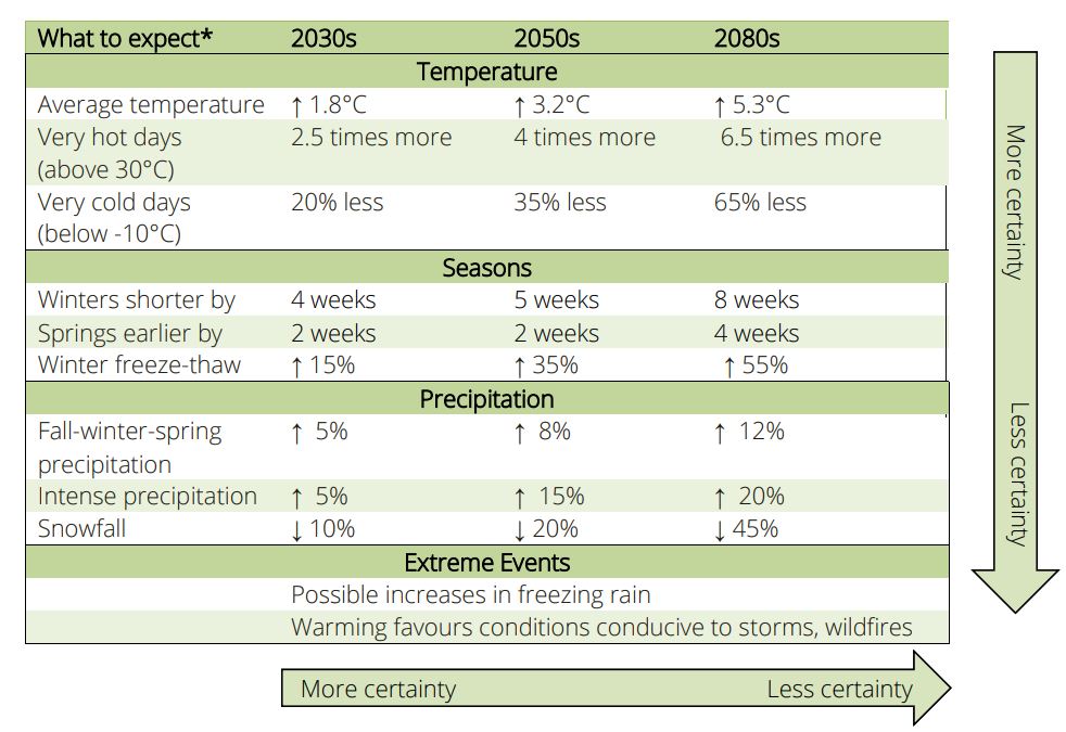
As mentioned above, the climate data behind the project as provided by the CCCS and used by CBCL Limited to develop climate projections for a large number of indices (178). The projections were derived from a combination of Global Climate Models (GCMs) and Regional Climate Models (RCMs). The indices, based on daily temperature and precipitation data, were computed using the same ensemble of climate simulations that are the foundation of ClimateData.ca, which consist of statistically downscaled GCM variables covering all of Canada at a resolution of approximately 6 x 10 km. To showcase changes in other variables, including sub-daily variables, including hourly precipitation rates, the City of Ottawa and the NCC sought additional data, some obtained by CCCS from collaborators (e.g., snow, snowfall, hourly precipitation and 3-hourly wind from RCMs participating in CORDEX), some acquired from ECCC (e.g., historical hourly precipitation), and some provided by University of Prince Edward Island Climate Lab (PRECIS).
How will these data be used?
These key findings have been invaluable in guiding decision-makers in their efforts to understand the impacts of climate change on the NCR and in developing effective adaptation strategies. They have been used to inform a wide range of initiatives, including climate vulnerability and risk assessments, asset management plans, transportation planning, emergency management planning, and public education and outreach. The results of the climate data and vulnerability and risk studies have been made publicly available, and have been shared through various platforms, including The City of Ottawa’s website, The National Capital Commission’s website, and social media, promoting a broader understanding of the effects of climate change on the NCR and the importance of adaptation planning.
Here are some additional detailed examples of how the climate data has or soon will be, utilized:
- Climate Vulnerability and Risk Assessments (CVRA) – CVRA is a process of evaluating the potential impacts of climate change and requires detailed climate model projections. CVRAs can be completed for sectors, programs, or projects.
- Asset Management Plans – Asset management refers to the systematic approach to managing an organization’s physical assets, including infrastructure, facilities, and natural assets. Climate data can be useful when developing asset management plans for water, wastewater, and stormwater services, for example.
- Emergency Management Planning – Effective emergency management requires a comprehensive understanding of the risks and vulnerabilities associated with climate change. These climate data can help decision-makers to understand the potential impacts of climate change on critical infrastructure and communities and to develop strategies for protecting public safety and minimizing harm.
- Transportation Planning – Transportation planning involves identifying and addressing the infrastructure and planning needs of a community related to transportation. Climate data can support regional transportation planning including the Transportation Master Plan, environmental assessments for specific projects, and the development of design and maintenance standards for transportation infrastructure.
- Health planning – Public health planning addresses the varied impacts of climate change on public health and safety such as increased heat-related illnesses, vector-borne diseases, and water and food-borne illnesses. It takes a comprehensive and integrated approach, considering physical, mental, and financial impacts, with a particular focus on more at-risk populations.
- Public Education and Outreach – Climate change is a complex and challenging issue that requires widespread public understanding and engagement. Because the data for this study was made publicly available through multiple channels, it is hoped that it can help build public understanding of the impacts of climate change in the region and to support broader engagement and action on this important issue.
Phase 3 of the Climate Resiliency Strategy for the City of Ottawa and the NCC is focused on developing and implementing climate resilience and adaptation initiatives. Building on the results from Phase 1 (climate projections) and Phase 2 (climate vulnerability and risk assessment), Phase 3 will use the risks identified in the climate vulnerability and risk assessment to guide decision-making and prioritize actions to mitigate the greatest risks. This phase is currently ongoing and is expected to result in concrete actions and plans to improve the NCR’s resilience to the impacts of climate change. These actions may include updates to infrastructure and asset management plans, emergency management plans, transportation planning, and design and maintenance standards. Additionally, public education and outreach efforts may be stepped up to continue building public understanding and support for climate resilience efforts in the NCR.
Conducting a comprehensive climate change projection study involves several challenges. Some of the biggest challenges to overcome include:
- Data Collection: Obtaining accurate and relevant data on past and current climate patterns is essential for the study. However, collecting and integrating data from multiple sources can be challenging, especially if the data is not consistent or reliable. In addition, it is challenging for non-experts to navigate the selection of indices that will support jurisdictional needs.
- Modeling Complexity: Projecting future climate changes involves complex modeling techniques that can be difficult to understand and interpret, especially for non-experts.
- Climate Uncertainty: Climate change projections can be subject to a high degree of uncertainty, and it can be challenging to quantify and communicate the uncertainty associated with the projections to non-experts. Some climate hazards, such as extreme weather events like tornadoes or ice storms, are not well reflected in climate models.
- Collaboration: Conducting a study that involves multiple partners, stakeholders, and departments can be challenging, especially if there are differing views about the approach, data, or results.
- Presenting Results: Presenting the results of a climate change projection study in a way that is accessible, understandable, and actionable can be a major challenge.
- Public Engagement: Ensuring that the results of the study are shared with the public and used to engage and inform them about the impacts of climate change can be a major challenge, especially if the public is not familiar with the technical aspects of the study.
Despite these challenges, compiling and discussing climate projections data is essential to building an understanding of future climate impacts, and determining how to use the information to build more resilient cities. Having localized projections provides consistent science to inform a wide variety of projects and plans for the National Capital Region and can be used by a range of stakeholders and agencies.
Working Together
The CCCS provides access to data and information as well as offers training and support on how to use climate information to support decisions that increase resilience to the impacts of climate change. http://canada.ca/climate-services
Of particular interest to municipalities, the CCCS maintains a list of Climate-related resources for local governments.
Readers are encouraged to contact the Support Desk for assistance: https://climatedata.ca/feedback/
Acknowledgement
This article would not have been possible without the invaluable contributions made by the staff at the City of Ottawa and the National Capital Commission. Thank you for providing your input and edits.