How do changes in climate patterns relate to weather hazards?
Climate-related hazards, such as heatwaves and floods, have become more frequent and intense in Canada and much of the globe.[1] This article is the first of a new series that will look at several different weather hazards and explore how rising temperatures and shifting climate patterns may affect the frequency, intensity, and duration of these hazards.
Climate represents the long-term average of weather (usually a 30-year average). Climatic zones (regions experiencing similar weather conditions) are often large. Weather hazards tend to be short-lived singular events that can lead to significant damage and disruption. How do changes in climate patterns relate to weather hazards?
This first article looks at freezing rain. Here we provide an overview of the latest data and research to shed light on how climate change could alter the frequency, severity, and geographical distribution of freezing rain events across the country.
Where does freezing rain tend to fall in Canada?
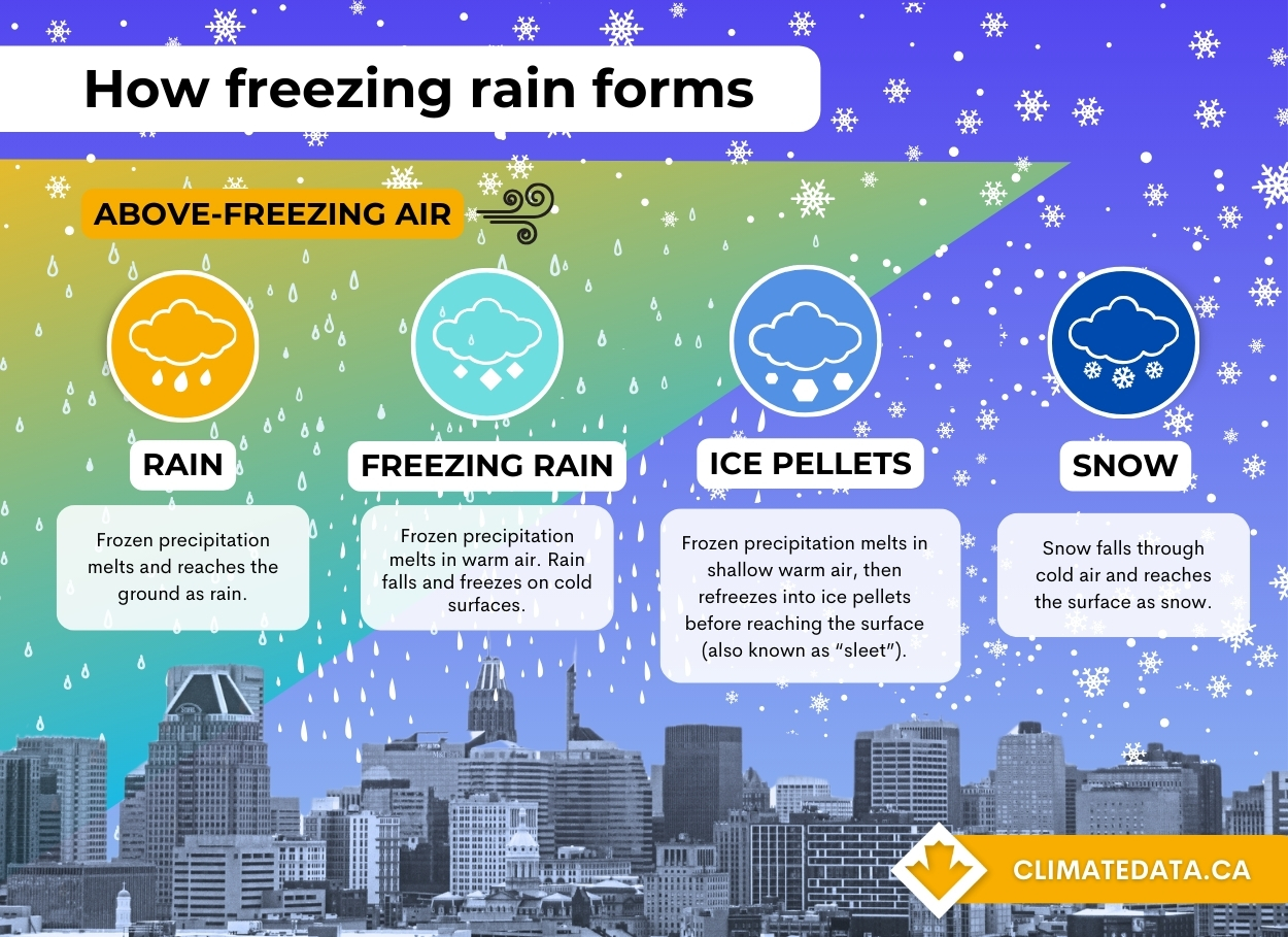
Freezing rain is most often observed in eastern Canada, particularly in regions like southern Québec, southeastern Ontario, and the Atlantic Provinces. During the winter season, these areas are more susceptible to the conditions that lead to freezing rain due to their geographical location and prevailing weather patterns.
The St. Lawrence River Valley is a notable hotspot for freezing rain events in Canada. Here, cold air sinks into the valley, cooling liquid raindrops as they fall from relatively warm air aloft. It is not uncommon for places like Ottawa and Montréal to experience numerous freezing rain warnings per year. In most cases, freezing rain events last a few minutes to a few hours. However, longer and more serious freezing rain events are possible, as witnessed during the infamous 1998 Quebec ice storm. During this event, more than 100 mm of mixed precipitation fell over five consecutive days, downing trees and powerlines, coating roads, and resulting in at least 40 deaths.
What research is being done on the impacts of climate change on freezing rain in Canada?
The relationship between freezing rain and climate change is an active area of research. A study by McCray, Paquin, Thériault, and Bresson (2022) used the Canadian Regional Climate Model (CRCM5) to project changes in freezing rain patterns across North America. Here are three key takeaways from their study:
- The frequency of freezing rain is expected to rise in parts of western and central Canada (Alberta, Saskatchewan, Manitoba) and decline across much of the United States.
- The specific method used to model freezing rain events affects the magnitude, but not the direction, of projected changes.
- The choice of global climate model used to drive the regional climate model greatly influences the predictions, indicating significant uncertainty in both the extent and direction of changes in freezing rain events.[2]
A different approach to modelling future freezing rain was undertaken as a part of the Climate-resilient Buildings and Core Public Infrastructure initiative (CRBCPI). The final CRBCPI report contains modelled climate parameters intended for use in infrastructure design (so-called ‘design values’), specifically buildings and bridges. One of these design values is ice accretion. Ice accretion can occur as a result of several different processes; however, freezing rain is the dominant cause of ice accretion in most locations in Canada, making it a suitable proxy – or stand in – for this hazard. CRBCPI’s ice accretion data project a similar poleward shift in future freezing precipitation conditions due to rising surface temperatures as noted by McCray et al. (2022). Confidence in projections of future ice accretion values is low due to the complexity of processes involved in the formation of ice accretion, and the limited spatial and temporal resolution of climate models.[3]
Explore the data
For those interested in the raw dataset utilized by McCray, Paquin, Thériault, & Bresson (2022), the annual freezing rain frequencies generated from each simulation and precipitation-type algorithm are available, for all of North America, here.
Ouranos has also made its freezing rain data available via its Climate Portraits data portal. On this site you can explore freezing rain maps and data, for Quebec only, summarized by:
- Annual number of hours of freezing rain
- Annual number of long-duration (>= 6 hour) freezing rain events
- Annual number of events with at least 10mm of freezing rain
Stay tuned for future articles on other climate-related weather hazards.