Get Climate Smart: North Atlantic Oscillation

Date February 10, 2026
Author Jaxton Gray and Ruth Moore, Canadian Centre for Climate Services
Topics Get Climate Smart, Seasonal to decadal forecasts
Share this post

Introduction – what is the North Atlantic Oscillation?

ClimateData.ca specializes in providing long-term projections of future climate to inform actions to build resilience to climate change. Now, ClimateData.ca also provides climate predictions on seasonal to decadal (S2D) timescales, consisting of probabilistic forecasts for upcoming seasons and years. S2D forecasts bridge the gap between weather forecasts and long-term climate projections. These shorter-term forecasts are strongly influenced by changes in ocean temperature and circulation patterns.

Ocean temperatures and circulation patterns are referred to as internal drivers of climate variability. Internal variability refers to natural changes that occur in the Earth system, driven by interactions between the atmosphere, oceans, and land, that are independent of external drivers of change such as greenhouse gas emissions. A well-known driver of internal variability in Canada is the El Niño-Southern Oscillation (ENSO) cycle. Another important driver of internal climate variability for Canada is the North Atlantic Oscillation (NAO). The NAO is the most important driver of climate variability in the North Atlantic (Visbeck et al., 2001) and a dominant factor controlling climate variability in eastern Canada (Qian et al., 2008).

The NAO is a climate pattern that results from the difference in sea level pressures (SLP) between two regions in the North Atlantic: the Azores High (a region of usually high pressure in the subtropical Atlantic) and the Icelandic Low (a region of usually low pressure near Iceland) (Figure 1). When the pressure difference between the regions is stronger than average, the NAO is in its positive phase, and when it is weaker than average, it is in its negative phase.

The changes in NAO phase influence winds, storms, precipitation and temperature across the North Atlantic, affecting the climate of Canada, the Arctic, Europe and the United States. These long-distance connections within the climate system are referred to formally as “teleconnections” (Box 1).

The positive phase of the NAO is typically associated with colder temperatures in the Canadian Arctic and warmer temperatures in southeastern Canada while the negative phase is typically associated with warmer temperatures in the Canadian Arctic and cooler temperatures in southeastern Canada (Figure 1). In this blog post we focus on how the NAO influences the climate and explore in more detail the effects of the NAO on Canada’s climate.

Figure 1: The NAO alternates between a positive phase—when the Canadian Arctic is colder and southeastern Canada is warmer—and a negative phase, when the Canadian Arctic is warmer and southeastern Canada is cooler. It is defined as the difference in sea-level pressure (SLP) between a region around Iceland (labelled L) and the Azores (labelled H). In the positive NAO phase, both the Icelandic Low and Azores High are stronger; in the negative phase, they are weaker. These changes in pressure shift the position of the North Atlantic jet stream (white arrow). The corresponding sea-level pressure differences are shown in Figure 2. Figure adapted from NOAA and the World Climate Service.

Box 1: What are climate teleconnections?

Teleconnections, a term derived from “tele,” meaning “at a distance,” describe the phenomena where weather and climate patterns in one region are influenced by climate events occurring thousands of kilometers away. The study of these patterns helps scientists understand how different parts of the climate system are interconnected.

Teleconnections occur, in part, because the climate system is linked by planetary-scale circulation patterns called Rosby Waves (Killworth, 2001). Rosby Waves form as air and water move between warmer and colder regions. The Earth’s rotation steers these waves, forming undulating, river-like patterns in both the atmosphere and oceans (Nigam and Baxter, 2015). Unlike the vertical motion of waves observed on a beach, Rossby waves primarily move horizontally and can extend across thousands of kilometers. Rossby waves can create persistent patterns of weather (high or low pressure) that are stable over weeks or even months.

These circulation patterns can act like a seesaw: when pressure is high in one area, it tends to be lower in the connected region.

How the NAO influences the climate

The alternating phases of the NAO can last for weeks to months (see Box 2 for how NAO phases are monitored), resulting in annual and seasonal climate variability. The phase of the NAO influences the North Atlantic jet stream, a high-altitude current of fast-moving air that helps steer weather systems (for more information please visit NOAA’s jet stream page), making the NAO an important driver of internal variability (Lindsey and Dahlman, 2009). Through interactions with the jet stream, the phase of NAO is associated with storminess (Lindsey and Dahlman, 2009) and the strength of westerly winds in the North Atlantic (Qian et al., 2008; Dutton, 2021). 

The NAO is strongly linked to another climate pattern, the Arctic Oscillation (Wettstein and Mearns, 2002; Lindsey and Dahlman, 2009; Brown, 2010; Dutton, 2021). In fact, there is active debate about whether these two patterns are separate phenomenon.

Box 2: Monitoring the NAO

The NAO is monitored by measuring the difference in SLP between two reference points, generally Reykjavik, Iceland and Lisbon, Portugal (Dutton, 2021). The difference in pressure between these points is compared with the long-term average pressure difference, resulting in the NAO Index (Figure 2). As mentioned in the introduction, when the pressure difference is greater than the average, the NAO is in a positive phase (red in Figure 2). When the pressure difference is less than the average, the NAO is in the negative phase (blue in Figure 2).
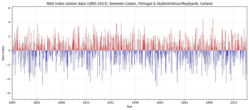
Figure 2: the NAO index between Lisbon and Reykjavik, showing the time series from 1865 to 2023. The positive phase is shown in red and the negative phase is in blue. Data available at NOAA.Another method of measuring the NAO index involves analyzing the pattern in SLP between areas around Iceland and the Azores, as opposed to using point-based station observations. This method is known as principal component analysis, and it allows for analysis of the overall spatial pattern of the NAO. More information on this method can be found on the NCAR website.

The NAO and Canadian climate

The oscillating phases of the NAO are typically associated with differences in temperature, precipitation and storms in eastern Canada.

Positive Phase

During the positive phase, the strong pressure difference between the Azores High and Icelandic Low strengthens the North Atlantic jet stream (Figure 1). The strengthened jet stream shifts storms northward, resulting in decreased storms in eastern North America and increased storms in Northern Europe.

The positive phase of the NAO is typically associated with predominately cooler and drier conditions in northeastern Canada and the Canadian Arctic and warmer and wetter conditions in southern Canada (Figure 1, Brown 2010, Dutton 2010). The positive phase is often associated with reduced precipitation over northern and eastern Canada (Bonsal & Shabbar 2008).  Over Hudson Bay, the NAO phase drives changes in sea-ice cover, with positive years tending to have early sea ice formation (Qian et al., 2008).

Negative Phase

During the negative phase, the weak pressure difference between the Azores High and Icelandic Low results in the North Atlantic jet stream having a more west-to-east orientation (Figure 1). The adjusted position of the jet stream means fewer storms in Northern Europe. In eastern North America, there tends to be more storms than normal, associated with the lower air pressure in the region.

During the negative phase, the eastern Canadian Arctic is warmer, and parts of southeastern Canada and the eastern United States are usually cooler (Brown, 2010) (Figure 1) with strong cold-air outbreaks more common across eastern North America (Lindsey and Dahlman, 2009). Southeastern Canada and the Eastern United states are usually drier (Bonsal & Shabbar 2008, Dutton 2010) while northeastern Canada is wetter due to winds from the Atlantic bringing warm and moist air to the region (Brown 2010).


Conclusion

The NAO is an important driver of the internal climate variability in North America, the Arctic, and Europe, particularly in the North Atlantic. In northeastern Canada, the two phases of the NAO can be used to understand variability in temperature, precipitation, sea ice and the frequency of storms.

Unlike the El Niño–Southern Oscillation (ENSO) that can be predicted months in advance, a change in NAO phase can only be predicted a week or two in advance. Improving the understanding of internal variability from teleconnections such as the NAO can lead to more accurate climate models and improvements in seasonal forecasts.


Further Reading

If you are interested in learning more about the NAO, how it is measured, how it influences the climate of Canada (and other countries surrounding the North Atlantic) and how the NAO phase can be predicted please visit the following resources:

If you’re interested in seasonal to decadal (S2D) forecasts or how they are influenced by internal climate variability, you can learn more on the S2D Landing Page:

References

Bonsal, B. and Shabbar, A., 2008. Impacts of large-scale circulation variability on low streamflows over Canada: a review. Canadian Water Resources Journal, 33(2), pp.137-154.

Brown RD. 2010. Analysis of snow cover variability and change in Québec, 1948–2005. Hydrological Processes, 24(14): 1929–1954. https://doi.org/10.1002/hyp.7565.

Dutton J. 2021. World Climate Service. What is the North Atlantic Oscillation (NAO)?. Accessed 11/12/2025. Available online at https://www.worldclimateservice.com/2021/08/26/north-atlantic-oscillation/.

Killworth PD. 2001. Rossby Waves. In: Steele JH (ed) Encyclopedia of Ocean Sciences. Academic Press: Oxford, 2434–2443.

Lindsey R, Dahlman L. 2009. National Oceanic Atmospheric and Atmospheric Administration. Climate Variability: North Atlantic Oscillation. Accessed 2025-10-23. Available at: https://www.climate.gov/news-features/understanding-climate/climate-variability-north-atlantic-oscillation

Nigam S, Baxter S. 2015. GENERAL CIRCULATION OF THE ATMOSPHERE | Teleconnections. In: North GR, Pyle J and Zhang F (eds) Encyclopedia of Atmospheric Sciences (Second Edition). Academic Press: Oxford, 90–109.

Qian M, Jones C, Laprise R, Caya D. 2008. The Influences of NAO and the Hudson Bay sea-ice on the climate of eastern Canada. Climate Dynamics, 31(2): 169–182. https://doi.org/10.1007/s00382-007-0343-9.

Visbeck MH, Hurrell JW, Polvani L, Cullen HM. 2001. The North Atlantic Oscillation: Past, present, and future. Proceedings of the National Academy of Sciences98(23): 12876–12877. https://doi.org/10.1073/pnas.231391598.

Wettstein JJ, Mearns LO. 2002. The Influence of the North Atlantic–Arctic Oscillation on Mean, Variance, and Extremes of Temperature in the Northeastern United States and Canada. Journal of Climate, 15(24), 3586-3600. https://doi.org/10.1175/1520-0442(2002)015<3586:TIOTNA>2.0.CO;2

Whan K, Zwiers F. 2017. The impact of ENSO and the NAO on extreme winter precipitation in North America in observations and regional climate models. Climate Dynamics, 48(5): 1401–1411. https://doi.org/10.1007/s00382-016-3148-x.

Zhao H, Higuchi K, Waller J, Auld H, Mote T. 2013. The impacts of the PNA and NAO on annual maximum snowpack over southern Canada during 1979–2009. International Journal of Climatology, 33(2): 388–395. https://doi.org/10.1002/joc.3431.