Guidance on Using the Vertical Allowances Dataset

Vertical allowance (VA) is a useful metric for coastal planning in Canada and can be used in climate change risk assessments and adaptation planning. VA is intended to guide how much an asset (e.g., hospital, pier, house) should be raised so that the probability of that asset flooding over its design lifetime does not increase as the climate changes.

Time to completion
12 min

Key Messages

  • The vertical allowance dataset does not replace the need for local projections or risk assessments, particularly in relation to critical infrastructure or developments.
  • Vertical allowance, in the context of sea-level change, refers to the recommended amount by which coastal infrastructure should be elevated or raised to minimize the risk of adverse effects from sea-level change on that asset.
  • The vertical allowance dataset provides recommended vertical displacements for a range of future climate change scenarios. These allowances account for global and local factors affecting sea-level change, including the local characteristics of tides and storm surges.
  • This dataset is designed to be used by coastal planners and engineers, land use planners, researchers, and other professionals to support resilient coastal infrastructure design and emergency planning.
  • When using vertical allowance for the planning or adapting of coastal infrastructure, it is necessary to consult with coastal engineers who understand the local context in which this variable will be applied, or to use the vertical allowance dataset as a complement to existing local data.
  • In areas where vertical allowance cannot be computed (Arctic north of 70°N), due to the current lack of sufficiently resolved storm surge models, coastal planners and engineers can consider relative sea level change, local context, risk levels, and scenario selection in planning and adaptation efforts.

Climate change impact on sea levels in Canada: The need for future projections

Communities and ecosystems along Canada’s 243,000 km coastline face both challenges and opportunities from climate change. By the end of the century, the average rise in global sea levels could exceed one meter.1 However, sea-level change varies from region to region, and local changes can differ substantially from the projected global average.

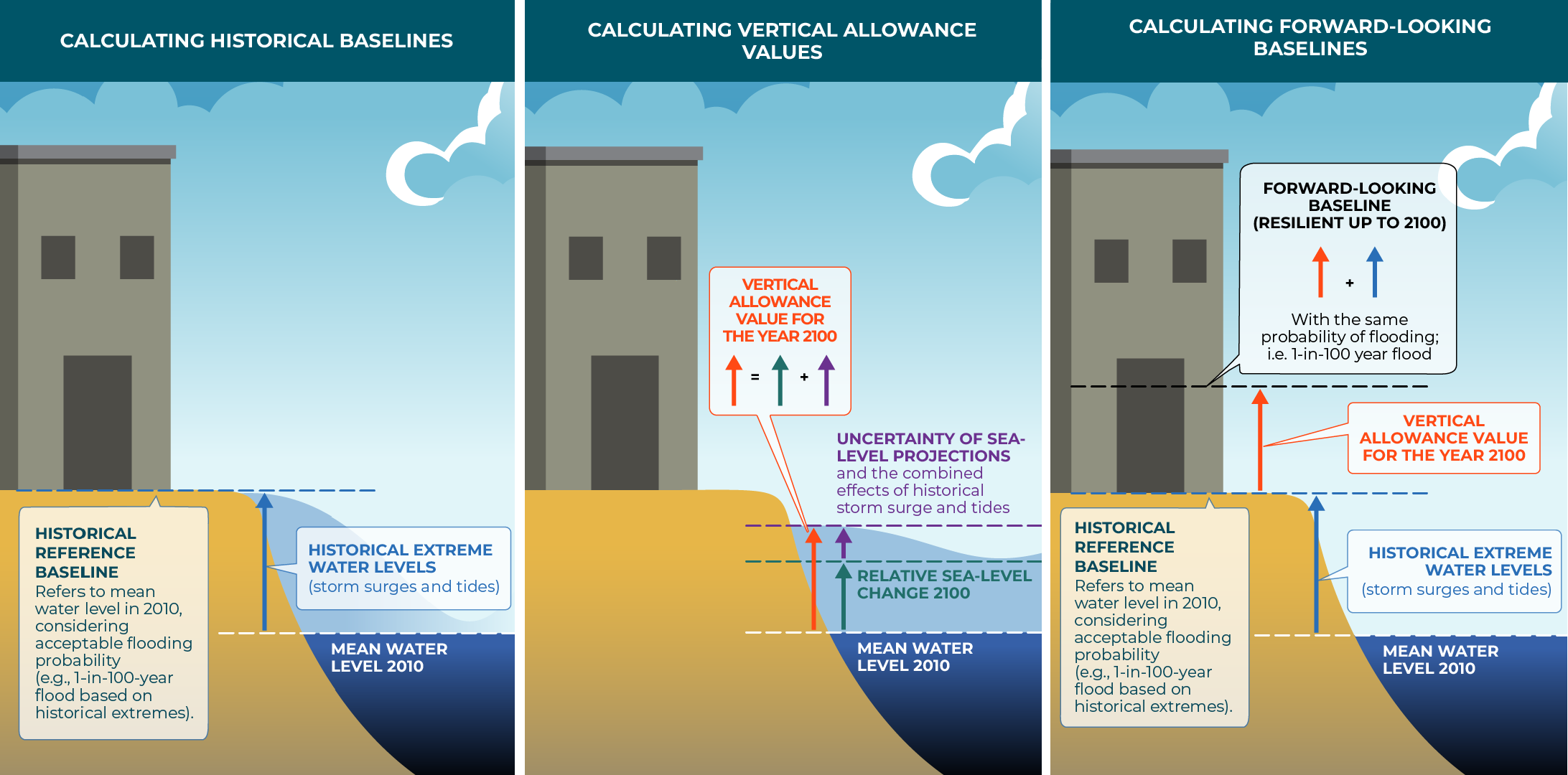
The differences in relative sea-level change in Canada are due to factors like local vertical land motion including subsidence (sinking) and post-glacial rebound (uplift). Most of the Atlantic and Pacific coasts of Canada, along with certain northern regions (e.g., the Beaufort coast in the Arctic) are projected to experience sea-level rise greater than the global average due to land subsidence, potentially increasing the frequency and magnitude of extreme water-level events in the coming century.2 On the other hand, locations in areas such as Hudson Bay, Nunavut, and northern Québec (i.e., Nunavik) may experience decreases in sea levels due to post-glacial rebound3.  Sea-level change in either direction may increase risks to infrastructure, ecosystems, and coastlines.  Thus, although the direction and extent of sea-level change differs by location, all coastal communities in Canada will need to prepare. Vertical allowances offer coastal communities a way to identify, assess, and respond to future sea-level changes.

What is the vertical allowance dataset?

Vertical allowance is the extra height added to a structure or the extra height by which a structure is displaced to protect it from future flooding. These adjustments to infrastructure design and placement are recommended based on a combination of historical and projected future coastal water levels and are tailored to the specific local environment. Vertical allowance (VA) is a useful metric for coastal planning in Canada and can be used in climate change risk assessments and adaptation planning. VA is intended to guide how much an asset (e.g., hospital, pier, house) should be raised so that the probability of that asset flooding over its design lifetime does not increase as the climate changes. If appropriate, practitioners may also consider using additional datasets to account for elements not included in the VA dataset (e.g., wave data).

Developed by Fisheries and Oceans Canada (DFO), the calculation of VA involves a combination of:

  • Historical water level records, including both tides and storm surge (referred to as storm tides) at tide gauge sites. To learn more, see the technical documentation4.
  • Storm-surge models that simulate historical storm tides and derive statistics of past extreme water levels4.
  • Regional sea-level change (RSLC) projections for widely used climate change scenarios spanning a wide range of potential greenhouse gas emissions: SSP1-2.6, SSP2-4.5, SSP3-7.0 and SSP5-8.5 (to learn more, see the Guidance on Using the Relative Sea-Level Change Datasets article).

To understand current flood risk, a historical reference baseline is established, which refers to a particular height relative to the mean water level. This baseline is calculated by combining the mean water level in 2010 with information about historical extreme water levels, such as storm surges and tides. It also incorporates an acceptable level of flooding, such as a 1-in-100-year flood event (see Figure 1, left). To understand how flood risks could change in the future, a forward-looking baseline is required.  The VA is added to the historical baseline to calculate the forward-looking baseline (Figure 1).

The VA for the time period of interest (2100 in this example) is calculated by combining the mean water level in 2010 with the relative sea-level change for 2100 and the uncertainty in the sea-level projections, as well as the combined effects of historical storm surges and tides on sea levels (Figure 1, centre).

Figure 1. Representation of the process for calculating historical baseline, vertical allowance and a forward-looking baseline. A historical reference baseline (left) combines historical extreme water levels and the mean water level for 2010. The vertical allowances are calculated by combining relative sea-level change for 2100 and uncertainty (centre). A forward-looking baseline combines historical data and future vertical allowance data (right) to improve infrastructure resiliency in the future.  RSLC and VA data are available on ClimateData.ca.

On ClimateData.ca, the climate models used to derive the VA dataset are from the Coupled Model Intercomparison Project Phase 6 (CMIP6) used by the Intergovernmental Panel on Climate Change (IPCC).

The VA dataset makes it possible to include the combined effect of storms and tides in future projections, along with relative sea-level change.

Available on ClimateData.ca, the VA dataset provides quick and easy access to the allowance values for a large part of Canada’s coastline. With different provinces and territories using different methodologies for allowances, having a standardized dataset for Canada makes it easier to compare across sites. In cases where specific local data exists, the VA should be considered as complementary.

Technical Details:

Vertical Allowance projections are available at a resolution of 0.1° (approximately 11 km latitude, 2 to 8 km longitude). The vertical allowances are provided from 2020 to 2150 for multiple emissions scenarios, ensuring that a range of future conditions are available for consideration.

Model uncertainty is already incorporated into the calculation of vertical allowance; therefore, the dataset does not include multiple percentiles for the multi-model ensemble. The coordinate system of the dataset is World Geodetic System 1984 (WGS 84) and the projection is EPSG: 4326.

The projections are offered on a high-resolution grid (approximately 10 km) and are relative to mean water level conditions in 2010.


Storm tides

As climate change impacts the likelihood and severity of storms, storm tides will interact with sea-level change. However, this interaction is not fully understood3, and the vertical allowance calculation assumes that the storm tides in the recent past are representative of the future. The VA dataset does not separate storm surges and tides into individual components but uses the combination of these processes as determined by the water levels measured at tide gauges or in storm surge model simulations.

Spatial coverage

The VA dataset is calculated for the marine coasts of British Columbia, Atlantic Canada, and the eastern Arctic below 70°N. Above that latitude, the VA values cannot be computed, due to the lack of storm surge models in the Arctic north of 70°N with sufficient resolution to match the granularity required for this variable. Learn more about the VA calculation in the variable description.

Guidance on the use of this dataset

Continuous vertical datum

When considering VA, it is important for coastal engineers to have accurate estimates of present-day water levels referenced to a standard vertical datum. A vertical datum provides a consistent reference for measuring water level.

The Canadian Hydrographic Service (CHS) has developed the Continuous Vertical Datum, calculating water level data, using the same ellipsoid and reference frame as VA (Robin et al., 2016)4.  This article will be updated with links to the CHS website once the continuous set of vertical datum is available for download. Meanwhile, data is available from DFO Small Craft Harbours and CHS tide gauge locations through the CAN-EWLAT tool (see the User Guide for navigation support).

Technical Note:

The vertical allowance dataset provided on ClimateData.ca defines latitude, longitude and ellipsoidal height with respect to Mean Water Level epoch 20104 to the Geodetic Reference System 1980 (GRS80) ellipsoid in the North American Datum of 1983 of the Canadian Spatial Reference System (NAD83(CSRS)) reference frame5.


For additional coastal datasets available for Canada, scroll to the Additional Resources section.


Which emissions scenario should I use?

In the near term (2020 to 2050), the VAs at a specific location are similar for the full range of climate scenarios, offering a robust foundation for shorter-term adaptation planning. However, beyond about 2050, the differences between the VAs for the different emission scenarios become more significant, and longer-term adaptation strategies will need to consider the risk tolerance of individual projects. For example, if the project is a piece of critical infrastructure, such as a power plant or hospital, users may need to choose an allowance based on a high emissions scenario1. The future is uncertain, and while change is inevitable, the precise nature of that change remains unknown, including the evolution of global emissions responsible for climate change. To address this uncertainty, multiple climate scenarios have been developed that represent a range of potential futures. Considering multiple climate scenarios is the best practice for accounting for uncertainty in potential futures. Ultimately, the project’s risk tolerance will dictate the number of climate scenarios that are considered.

For more information on climate scenarios, see these Learning Zone articles:


What are the limitations of the vertical allowance dataset?

The VA dataset on ClimateData.ca offers high-resolution projections from 2020 to 2100 for multiple emissions scenarios. This dataset is designed for use by coastal planners, engineers, and others looking to incorporate sea-level change into their planning for infrastructure along Canada’s coasts. However, there are several limitations that need to be considered when applying this data to coastal adaptation projects:

  • Data only relates to inundation, and not erosion of soft shorelines, or impacts associated with this erosion5.
  • Data are only available for part of the marine coastline of Canada (only south of 70°N) and do not cover river estuaries where freshwater flow is more important.
  • The variable calculation assumes the statistics of storm tides will not change with time. While climate change may influence storm tides directly, the impact of this on the allowances is expected to be small since sea-level change is the main factor driving changes in extreme water levels.5
  • Learn more about the limitations in the variable description.

For comprehensive planning, it is recommended to use this dataset alongside other relevant data to navigate these limitations effectively. For more information on how climate change impacts Canada’s marine and coastal regions, and to learn about other relevant marine datasets and tools, please visit the Marine Overview page.

Additional Resources

  • Guidance on using Relative Sea-Level Change datasets
  • Relative Sea-Level Change (CMIP6): On ClimateData.ca, projected RSLC data are available for the entire Canadian coastline, for every decade from 2020-2100, relative to 1995-2014 conditions, at a resolution of 0.1° in latitude and longitude.
  • Relative Sea-Level Change (CMIP5): Projected RSLC data are available for the entire Canadian coastline, for 2006 and for every decade from 2010-2100, relative to 1986-2005 conditions, at a resolution of 0.1° in latitude and longitude.
  • CanCoast – Coastal Materials Version 2.0: Geospatial database of the physical characteristics of Canada’s marine coasts. Includes both feature classes that are not expected to change through time, and feature classes that are expected to change as climate changes: wave-height change with sea ice; sea-level change; ground ice content; coastal materials; tidal range; and backshore slope.
  • Coastal Adaptation Toolkit: Includes two online tools – one for Communities, and one for Property Owners – and a companion resource containing three guidance documents. To help communities and property owners build awareness of their coastal environment, their different adaptation options available, and the applicability of the options under different scenarios.

References

  1. Fox-Kemper, B., H.T. Hewitt, C. Xiao, G. Aðalgeirsdóttir, S.S. Drijfhout, T.L. Edwards, N.R. Golledge, M. Hemer, R.E. Kopp, G. Krinner, A. Mix, D. Notz, S. Nowicki, I.S. Nurhati, L. Ruiz, J.-B. Sallée, A.B.A. Slangen, and Y. Yu, 2021. Ocean, Cryosphere and Sea-level Change. In Climate Change 2021: The Physical Science Basis. Contribution of Working Group I to the Sixth Assessment Report of the Intergovernmental Panel on Climate Change [Masson-Delmotte, V., P. Zhai, A. Pirani, S.L. Connors, C. Péan, S. Berger, N. Caud, Y. Chen, L. Goldfarb, M.I. Gomis, M. Huang, K. Leitzell, E. Lonnoy, J.B.R. Matthews, T.K. Maycock, T. Waterfield, O. Yelekçi, R. Yu, and B. Zhou (eds.)]. Cambridge University Press, Cambridge, United Kingdom and New York, NY, USA, pp. 1211–1362, DOI: 10.1017/9781009157896.011.
  2. Greenan, B.J.W., T.S. James, J.W. Loder, P. Pepin, K. Azetsu-Scott, D. Ianson, R.C. Hamme, D. Gilbert, J-E. Tremblay, X.L. Wang, and W. Perrie, 2019. Changes in oceans surrounding Canada; Chapter 7 in (eds.) Bush and Lemmen, Canada’s Changing Climate Report; Government of Canada, Ottawa, Ontario, p. 343- 423.
  3. Lemmen, D.S., Warren, F.J., James, T.S. and Mercer Clarke, C.S.L. editors (2016): Canada’s Marine Coasts in a Changing Climate; Government of Canada, Ottawa, ON, 274p.
  4. Robin, C., S. Nudds, P. MacAulay, A. Godin, B. De Lange Boom and J. Bartlett, 2016. Hydrographic Vertical Separation Surfaces (HyVSEPs) for the Tidal Waters of Canada, Marine Geodesy, 39:2, 195-222, DOI: 10.1080/01490419.2016.1160011.
  5. Zhai, L., Greenan, B.J.W. and Perrie, W. 2023. The Canadian Extreme Water Level Adaptation Tool (CAN-EWLAT). Can. Tech. Rep. Hydrogr. Ocean. Sci. 348: iii + 15 p.