How Future Climate Data Can Help
Using climate data to show trends in future extremes and extreme events can be challenging. One indicator of heavy snowfall events is maximum 1-day snowfall, which depicts the largest amount of snow that falls within a single 24-hour day for a selected temporal frequency and is available with the snowfall projections on ClimateData.ca.
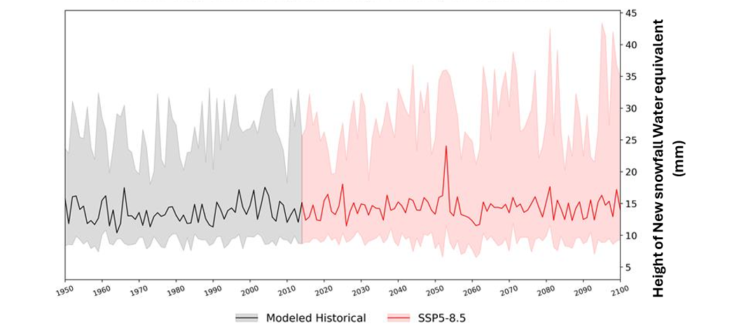
Figure 2 shows projected changes in maximum 1-day snowfall for Kangiqtugaapik under a high-emissions scenario through 2100. The red line shows the median projection, or the middle value across all models. The shaded area represents the spread of results: the lower edge (10th percentile) marks the level at which 90% of model results will exceed this value, while the upper edge (90th percentile) marks the level at which only 10% of model results will be higher.
The median maximum 1-day snowfall in Kangiqtugaapik is not expected to increase significantly (Figure 2), even under the highest emissions scenario. However, the upper limit (90th percentile) shows that by the end of the century, there is a possibility of an increase in single-day snowfall events. This scenario is less likely than the median outcome, but it highlights the potential for continuing heavy snowfall events in the future.